|
scrutiny
coventry |
16 of 34
Wed 19th Sep 2012 11:15am
Hi, The Spittalmoor is still there on the corner of Lower Ford St / Hood St but no longer a pub. Had a pic of it but lost it. |
| Local History and Heritage - River Arthur / Springfield Brook / Endemere Water | |
|
Annie
Coventry |
17 of 34
Fri 10th Feb 2017 9:45pm
I was born at 39 Springfield Road in 1958. The brook ran behind our garden and often the garden flooded until the brook was covered up and the gardens extended over it
My dad told me there were once fish in the brook until residents started to throw rubbish into it Question |
| Local History and Heritage - River Arthur / Springfield Brook / Endemere Water | |
|
Midland Red
|
18 of 34
Fri 10th Feb 2017 10:51pm
There are numerous mentions of "Springfield Brook" within the forum, in a variety of threads - it would be difficult to bring them all together
By entering "Springfield" in the search box, the relative posts can be seen |
| Local History and Heritage - River Arthur / Springfield Brook / Endemere Water | |
|
Prof
Gloucester |
19 of 34
Sun 26th Aug 2018 9:19am
Well there is, or was, Arthur St in that area. |
| Local History and Heritage - River Arthur / Springfield Brook / Endemere Water | |
|
Annie
Coventry |
20 of 34
Wed 29th Jun 2022 11:28pm
The brook ran at the end of our garden.
It was covered over in the early 60s and our gardens extended over it.
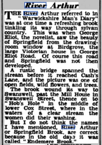
My gran and Aunt who lived next door since 1939 said the River Arthur was Springfield Brook. |
| Local History and Heritage - River Arthur / Springfield Brook / Endemere Water | |
|
Helen F
Warrington |
21 of 34
Thu 30th Jun 2022 10:54am
I can't find a map with the brook ever being called the River Arthur but there were periods where bits of the Sherbourne had local names for what must have been less than 100m, so why not the others. The name Springfield Brook makes sense because it partly started in the city's spring fields area. As many have noted, it can then be traced back to the stream that fed the Swanswell Pool, but that in turn is fed by streams from the north. The canal cuts off those small streams. Were they culverted under the canal or redirected? How big those streams were originally we'll never know. The Spital Moor Brook comes from the north east (Stoke) direction and joins the Springfield Brook just as it turns south towards Gosford Gate. The source of that brook may also have been affected by the creation of the canal. At Gosford the water flow was redirected on more than one occasion, including during the Civil War. There were multiple drainage/irrigation ditches and sluices, including ones that could in theory flood the city ditch. |
| Local History and Heritage - River Arthur / Springfield Brook / Endemere Water | |
|
Annewiggy
Tamworth |
22 of 34
Thu 30th Jun 2022 12:55pm

|
| Local History and Heritage - River Arthur / Springfield Brook / Endemere Water | |
|
PhiliPamInCoventry
Holbrooks |
23 of 34
Thu 30th Jun 2022 1:44pm
Hi all,
Water courses, tracing them whether using maps or walking, for me are fascinating.
For most of us city dwellers, living on top of concrete & tarmac, it's not easy to visualise myriads of such everywhere under our feet.
I was bread and buttered in Sewall Highway, the section between Dennis Road & the Devon. Houses on both sides but the houses on the even number side were the last. At age seven, 1954, having read a Rupert adventure, my chum & I set off walking through to the fields behind the last row of houses, then on to Bulkington. It was all mostly fields. Henley Road hadn't been developed then, just the remnants of Craven colliery.
The thing that I remember, is the number of times that we had to cross streams & brooks. They were everywhere. I saw frogspawn for the first time in some of the brooks.
The hard metalling of developed land, it's so easy to forget or not realise what's underground.
My chapel in Durbar Avenue is built over a spring, so a well with an evacuation pump is there working night & day to prevent flooding.
Thank you all for your posts on this lovely subject. |
| Local History and Heritage - River Arthur / Springfield Brook / Endemere Water | |
|
Helen F
Warrington |
24 of 34
Thu 30th Jun 2022 1:45pm
Yes Anne, the British History Online calls it the Endemere Brook. |
| Local History and Heritage - River Arthur / Springfield Brook / Endemere Water | |
|
Helen F
Warrington |
25 of 34
Thu 30th Jun 2022 10:05pm
On 30th Jun 2022 1:44pm, PhiliPamInCoventry said:
The hard metalling of developed land, it's so easy to forget or not realise what's underground.
You've got to love an old map. Seeing the ghost of old features is fascinating. |
| Local History and Heritage - River Arthur / Springfield Brook / Endemere Water | |
|
Midland Red
|
26 of 34
Fri 1st Jul 2022 8:18am
On 30th Jun 2022 1:45pm, Helen F said:
Yes Anne, the British History Online calls it the Endemere Brook.
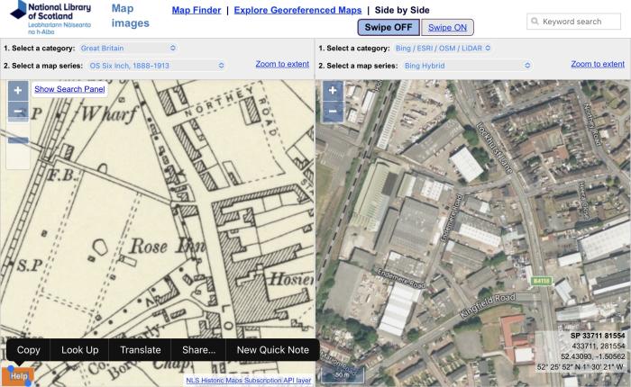
Endemere Road 
|
| Local History and Heritage - River Arthur / Springfield Brook / Endemere Water | |
|
Helen F
Warrington |
27 of 34
Fri 1st Jul 2022 8:58am
Thanks MR, I had noticed the road but is it a chicken and egg situation? Was the road named after the old river name or was the river once named after the place? Quite a few modern roads have been given ancient names without there being an actual link. Sadly the Coventry Collections search is still not working or I'd search for Endemere. I did find a reference in the National Archives for 'Endermer', where it describes the boundaries for Foleshill, which looks promising.
First, the parish begins at the further hedge of Boyswast against Stake Croft, including that waste, and so descending by the hedge of le Hoo as far as Thelebroke, and so by the brook as far as Lady lane, and thence ascending by the said lane towards the east as far as the further corner of le Mordyffe (including it), and thence across the end of Woodlane by the ditch as far as the way opposite the house which was formerly William Bagot's (including le Ruydynges and le Wethersfeld) as far as the cross which stands before Henry Ive's gates (here end the parishes of Sowe, Foleshill and Wyken). And from that cross going down towards Foleshill by the highway to the hedge and ditch which divide Wyken and Henley as far as Henley Broke. And so by that way continuing to Milesmedowe (including that meadow) as far as the corner of Deedmore, and so climbing by the watercourse coming from Caloudon Waste well, and by that well straight to Wattonsfeild (including that field) as far as Hasilwood, including the whole of Henley lordship, and so by Hasilwood as far as Redeslow, and so reverting by Harnalwast ditch (excluding that waste) as far as Brodehoke, and thence crossing the highway there as far as the further hedfge of le Ruydynges (of hospital of St. John) and so by the two aforesaid fields' ditch (le Ruydynges) and by the croft called le Stripe as far as Ouenotteford, and so ascending by Endermer water as far as le Slowe in Lecardeslane, and thence turning to the corner of Whitmore park, and so by the said park's ditch as far as Walsichelane, and so by that lane as far as the highway which leads towards [Newland] and divides Foleshill and Keresley as far as Lullehurstlane, including the whole of Corley waste and le Farthyng Hey, and so descending by the brook as far as the corner of Huglond, and so climbing by the hedge and ditch between Huggland and William Holbroke's land as far as the said William's land (including it) as far as the land formerly Ralph Grene's, and so to the well between Ralph Grene's and Thomas Grene's, and straight from the well to Gibbelane, and so across le Gibelane as far as the land which formerly Elias Milleward and now Robert Swale holds (including it) as far as the highway which leads to Wolpitledyate. And so by that way directly as far as Maggeleys, and so in a straight line by the boundary as far as the way which leads from Coventry towards [Nuneaton] where Foleshill and Exhall parishes come together, and so directly by that way as far as Shittehurmeway, and thence as far as Shittecroftcorner, and thence to Sydenal Gate coming from Exhall, and so following by Merstoneway as far as Preisteswoodende, and so following le Preistes Wood as far as le Hay, and so by le Hay's ditch as far as Boyswast, and so Sydenhall Wood, le Breches and le Sydeles, and whatever is contained between Merstone Way and Foleshill Gate and Blakemoore as far as the pen which William in the Close now holds [where] Foleshill and Exhall parishes are mixed together.
|
| Local History and Heritage - River Arthur / Springfield Brook / Endemere Water | |
|
Helen F
Warrington |
28 of 34
Fri 1st Jul 2022 11:05am
I've found Stripes Farm and 'Ouenotteford' seems to be where Cash's Lane crosses the Springfield Brook. Then the boundary runs north along the brook 'so ascending by Endermer water'.
'Ouenotteford' sounds like part of an instruction - when not to ford... |
| Local History and Heritage - River Arthur / Springfield Brook / Endemere Water | |
|
Midland Red
|
29 of 34
Fri 1st Jul 2022 11:15am
Helen, what do you know about Shittehurmeway and Shittecroftcorner? |
| Local History and Heritage - River Arthur / Springfield Brook / Endemere Water | |
|
Helen F
Warrington |
30 of 34
Fri 1st Jul 2022 11:46am
|
| Local History and Heritage - River Arthur / Springfield Brook / Endemere Water | |
This is your first visit to my website today, thank you!
4,109,427Website & counter by Rob Orland © 2024
Load time: 692ms