|
NeilsYard
Coventry |
61 of 163
Tue 15th Aug 2017 8:22am
Sorry Rob - missed your last post for some reason. That's brilliant - thanks yet again matey |
| Local History and Heritage - Maps of Coventry | |
| Rob Orland |
62 of 163
Tue 15th Aug 2017 9:17am
|
|
Old Lincolnian
Coventry |
63 of 163
Fri 27th Oct 2017 9:26am
For a while now the National Library of Scotland has been in the process of uploading a huge database of old Ordnance Survey maps of England, Scotland and Wales from Victorian times to the 1960's in all scales up to 25" to the mile, showing a wealth of detail. The service is free although the site is not the most intuitive to use but the quality of the maps is superb.
National Library of Scotland OS Maps |
| Local History and Heritage - Maps of Coventry | |
|
Helen F
Warrington |
64 of 163
Thu 14th Dec 2017 12:05pm
In praise of the Board of Health Maps (approx. 1850).
There has been a lot of work done trying to understand Coventry's medieval or pre factory details and surprising few experts have used the Board of Health Maps to their full potential. Not only are those maps a work of art, they contain invaluable details. Yard names often indicate who owned them or the business that fronted them. The plots of each house are remarkably accurate even showing where doorways were (marked by a dot and the height above datum level). Sheds, garden features, steps and even some cellar chutes are marked. The detail is incredible.
Due to some of the smallest features, I've been able to locate almost all of the obscure images of Coventry I've got hold of. Without those maps, many of the pictures of yards and the rears of properties would have been impossible to place.
An overview of the Board of Health map in Rob's records
So if you're trying to research any place before 1888, seriously consider popping into the History Centre and get a photo copy of the appropriate map. It will save you a lot of time. It might even persuade the Herbert to create a decent set of copies. |
| Local History and Heritage - Maps of Coventry | |
|
Helen F
Warrington |
65 of 163
Mon 7th May 2018 10:12am
1840 map of Coventry
Not very detailed but not a map I'd seen before |
| Local History and Heritage - Maps of Coventry | |
|
Helen F
Warrington |
66 of 163
Mon 9th Jul 2018 12:38pm
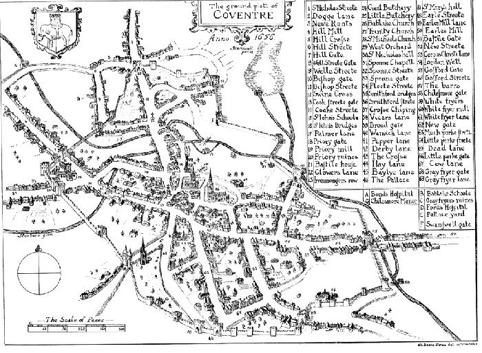
Back in 2011 member K pointed out that there was a 1656 version of Speed's 1610 map.
 Does anyone have a clear copy of this map? I know that there is one in Coventry Illustrated Souvenir, A Series Of Sketches And Historical Notes, 1946 but I've yet to secure a copy.
|
| Local History and Heritage - Maps of Coventry | |
|
Annewiggy
Tamworth |
67 of 163
Mon 9th Jul 2018 12:59pm
Helen, that map is in the back of Coventry six hundred years of municipal life, by Frederick Smith but it does not seem any clearer than that. I can try scanning that for you. It also says it is from Dugdale's Antiquities of Warwickshire |
| Local History and Heritage - Maps of Coventry | |
|
heathite
Coventry |
68 of 163
Mon 9th Jul 2018 1:02pm
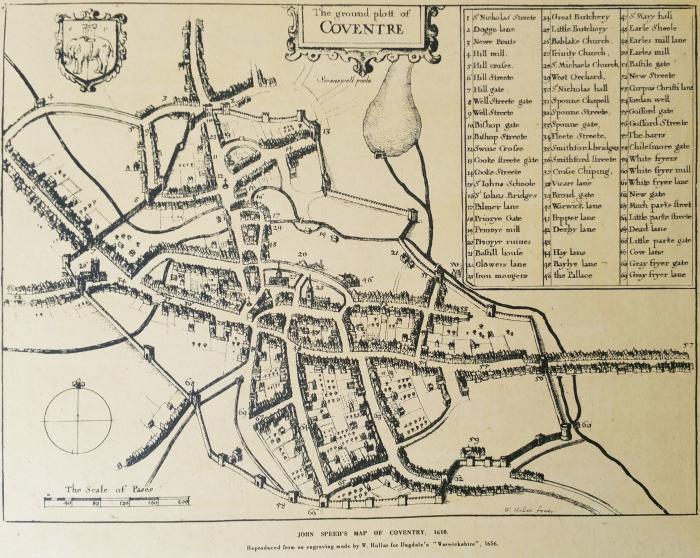
I have a print of this, below the map on the print it reads " John Speed's Map Of Coventry, 1610
Reproduced from an engraving made by W. Hollar for Dugdale's "Warwickshire", 1656.
The print measures approximately 16 x 12 inches.
I took a photo and have a 3.66 MByte file. If you would like the original file . . .

|
| Local History and Heritage - Maps of Coventry | |
|
Helen F
Warrington |
69 of 163
Mon 9th Jul 2018 1:09pm
Thanks Heathite, though I have a copy of that version. I didn't notice the differences before but it's not the same as the 1656 version. There must have been more than one version of Dugdale's Antiquities? The north and south prospect of Coventry was probably produced in 1656 but in some copies they use the earlier map.
Please Anne, if your version is the later copy, I'd love a scan.
There is even a third version of the map, that some will be familiar with - where the buildings are much less varied. |
| Local History and Heritage - Maps of Coventry | |
|
heathite
Coventry |
70 of 163
Mon 9th Jul 2018 1:20pm
There's one for sale here, I think. |
| Local History and Heritage - Maps of Coventry | |
|
Helen F
Warrington |
71 of 163
Mon 9th Jul 2018 1:27pm
Thanks again. I'm not sure how legit that site is. I couldn't find out much about it. While there are companies I buy from overseas, I'm reluctant to go far off the main players outside the UK.
PS It occurs to me that the souvenir may have been compiled from the book Anne mentions. The version may even have been updated by the author Frederick Smith. |
| Local History and Heritage - Maps of Coventry | |
|
mcsporran
Coventry & Cebu |
72 of 163
Mon 9th Jul 2018 1:30pm
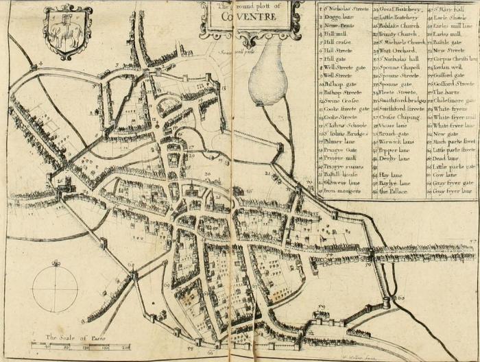
The internet archive has Dugdale's Antiquities of Warwickshire but the map seems to be the 1610 one. It's page 87 in their version, zoom in for detail. |
| Local History and Heritage - Maps of Coventry | |
|
heathite
Coventry |
73 of 163
Mon 9th Jul 2018 1:48pm
Here's a grab of it, but don't tell anyone. 
|
| Local History and Heritage - Maps of Coventry | |
|
Helen F
Warrington |
74 of 163
Mon 9th Jul 2018 2:01pm
The key difference with the 1656 version is the date Anno 1656 below the Coventre and the depiction of the Greyfriars steeple, noticeably absent from the 1610 version. Here's the picture from the polestars site.

|
| Local History and Heritage - Maps of Coventry | |
|
Annewiggy
Tamworth |
75 of 163
Mon 9th Jul 2018 2:27pm
Sorry Helen, the one I mentioned in the book must be the earlier version although it says 1656 on the bottom it does not have the steeple. |
| Local History and Heritage - Maps of Coventry | |
Website & counter by Rob Orland © 2024
Load time: 719ms