 From there the wall followed the river and then crossed it and headed north to a tower and then west. The photos are of the stretch north and west. They don't seem to have found a tower.
|
Helen F
Warrington |
46 of 259
Fri 27th Apr 2018 8:33pm
Not quite Anne but not far away. The two sections were on the other side of the river. The Bastille mill was at the End of what is now Cox Street (I think).
 From there the wall followed the river and then crossed it and headed north to a tower and then west. The photos are of the stretch north and west. They don't seem to have found a tower.
|
| Local History and Heritage - City Wall and Gates (inc. Cook Street) | |
|
Rob Orland
Historic Coventry |
47 of 259
Sat 28th Apr 2018 10:23am
On 27th Apr 2018 8:11pm, Annewiggy said:
That's interesting Helen, I wonder if it was the part of the wall where Earls/Bastille Gate was situated as that was where one of my ancestors lived.
Here it is Anne! (Highlighted in red, near Ford Street.) I updated my "City Wall & Gates" page soon after taking photos of the newly excavated corner tower. It quite excited me at the time, because previously I could only guess from 300 to 400 year old maps, not necessarily to scale, as to where that part of the wall turned the corner, at what I presume was a watchtower.
As it turned out, the location I'd plotted on my hand-drawn map was only about 10 yards away from its true position, once I was able to use the Google aerial view to establish it. |
| Local History and Heritage - City Wall and Gates (inc. Cook Street) | |
|
Prof
Gloucester |
48 of 259
Thu 21st Jun 2018 3:23pm
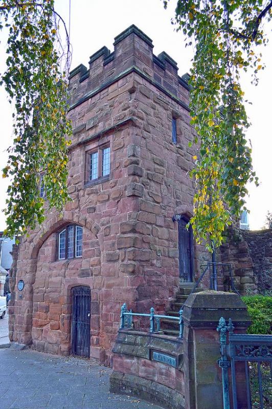
Here is a nice view of Priory or Swanswell Gate.
|
| Local History and Heritage - City Wall and Gates (inc. Cook Street) | |
|
Prof
Gloucester |
49 of 259
Thu 21st Jun 2018 8:02pm
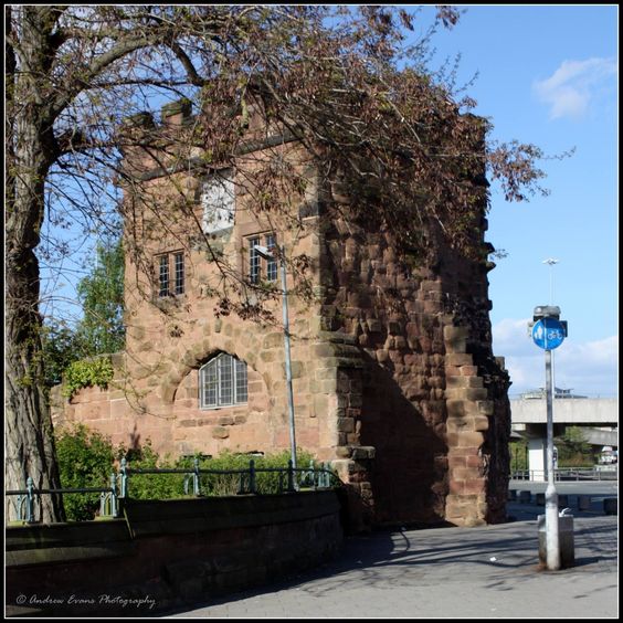
Here is another of Priory or Swanswell Gate with part of the surviving wall
|
| Local History and Heritage - City Wall and Gates (inc. Cook Street) | |
|
Prof
Gloucester |
50 of 259
Fri 22nd Jun 2018 10:39am
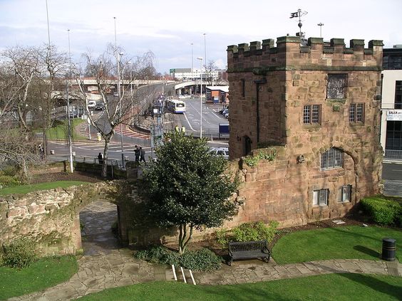
Another of Priory Gate showing a longer stretch of wall. I attribute these photos to Arnold Frederick Storey
 |
| Local History and Heritage - City Wall and Gates (inc. Cook Street) | |
|
Prof
Gloucester |
51 of 259
Thu 28th Jun 2018 10:21am
I am wondering Rob whether this question has ever been resolved: I think, from as early as Levi Fox's 'Coventry's Heritage', it is stated Coventry had twelve gates and twenty-two towers. That seems an awful lot for a comparatively small area. I believe I read the suggestion that instead it could be twelve gates and ten towers, making the same total! Have you the means to clarify this interesting point? I see Annewiggy mentions Thornton's History which says: "It contained thirty-two towers, including twelve gates." Perhaps I had forgotten 32 and in memory made it 22. Gates included makes a difference of course. |
| Local History and Heritage - City Wall and Gates (inc. Cook Street) | |
|
Annewiggy
Tamworth |
52 of 259
Thu 28th Jun 2018 11:14am
Prof, Speeds 1610 map shows about 32 towers and gates. There are quite a few on the southern section of the wall. |
| Local History and Heritage - City Wall and Gates (inc. Cook Street) | |
|
Prof
Gloucester |
53 of 259
Thu 28th Jun 2018 11:39am
Thanks Anne, that confirms it, I should have looked more closely! Did you do the walk? I used to take visitors round to see parts of it, near the Belgrade/Well St and Gosford St I think, as well as the two surviving gates.
Long stretch in Gulson Rd but guess this was re-built at some time and may not be on original site exactly?
I now notice the informative Coventry 2018 map showing the whole area of the wall shows that the Gulson Rd
stretch is in original position, though much reduced in height. |
| Local History and Heritage - City Wall and Gates (inc. Cook Street) | |
|
Annewiggy
Tamworth |
54 of 259
Thu 28th Jun 2018 11:42am
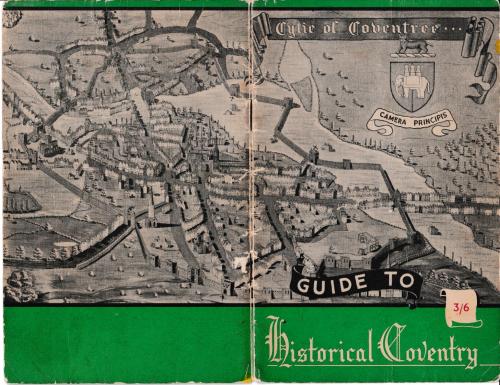
Ok Prof, You can see most of them on this cover of an interesting booklet
|
| Local History and Heritage - City Wall and Gates (inc. Cook Street) | |
|
Prof
Gloucester |
55 of 259
Thu 28th Jun 2018 1:39pm
Thank you Annewiggy. Never seen that before. I have a very old Coventry Guide with b&w photos that must be c.1905 which is the year my grandfather left his native Grantham to come and work at the Ordnance Works where he was a skilled toolmaker, later working at the Alvis until his death in 1948. This also helped spark my interest in local history, confirmed by Levi Fox's book we were given to read at Gosford Park School. Strange how the wall in the area of Cook Street and Swanswell Gates on RH looks as if the wall was built over the Sherbourne! |
| Local History and Heritage - City Wall and Gates (inc. Cook Street) | |
|
Helen F
Warrington |
56 of 259
Thu 28th Jun 2018 1:56pm
The confusion comes from the different types of structures in the wall. Some were solid, some had proper gateways, some were postern gates ie just small doorways to allow locals access to the fields, some were vents in the wall to allow water in or out. The wall also had a long and varied history and some of the structures fell down or were removed for access. The prospects (views) of the city don't seem to match the maps but that's because they haven't shown proper perspective so two walls get melded together but are actually some distance apart.
As best as I can gather from the north:
Bishop Street Gate
Munition magazine tower (as big as a gateway)
Round tower
Corner round tower
Cook Street Gate (no towers)
Swanswell Gate
Corner round tower
River vent (may have had something over but not shown)
Bastille Gate
Tower/possible postern gate
Corner of walls (probably had a tower there at one point but not on the maps)
Gosford Gate (original tower incorporated into St George's Chapel)
Corner big round tower
Tower/possible postern gate? Dragon gate?
Tower
Tower/possible gate/possible Lady Tower (see below 1)
Tower/possible gate/possible Lady Tower
New Gate (originally it probably had towers but was nevertheless a very big building)
Corner tower (sawn off octagon civil war feature)
Tower/gate small (postern)
Tower/gate small (postern)
Tower/gate small (postern)
Little Park Street Gate
Cheylesmore Gate
Tower/possible postern gate?
Old hall of Cheylesmore Manor within the wall
Possible tower for Cheylesmore Manor or gate unknown (see below 2)
Greyfriars Gate with towers
What looks like a gate with towers leading to The Bull but may be river vent (see below 3)
River vent
Spon Street Gate with towers
Corner tower
Hill Street Gate
River vent (Radford Brook, small may not have needed tower)
Well Street Gate
Munition magazine tower (as big as a gateway)
Small round tower still there
Small tower still there
Note 1
The Whitefriars Cermelite monastery had two roads, one to Much Park Street and one to Gosford Street. It may have had a third, exiting onto London Road, although this would have made it vulnerable. Instead it may have had a postern gate (ok for single file and un-ridden horses). In war it could be blocked up and the bridge quickly removed. The map shows three towers. The middle one would be logical as a gate/postern gate as it relates to the paths inside the grounds.
In addition - The Carmelites were a mendicant religious order, dependent on charity from those they taught and on the gifts from pilgrims visiting their shrine of Our Lady of the Tower. According to Dugdale, 'This Chapell is in the tower of the Cittye Wall without New Gate, close by the roadway leading towards London. On the outside thereof was a picture of the blessed Virgin, richly painted, and within an image and her altar, whereat most travellers which passed by did offer more or lesse, out of confidence that their journey would be better blest'. So one of the three towers was the Lady Tower. Unsuitable I'd have thought to use it as a gateway or postern gate. Another clue is that the Salutation Inn was supposed to be roughly opposite, for travellers to donate to a different type of icon. It was also said that locals would just salute the chapel instead of entering, hence the name. The leftmost tower of the group of three is the closest to the modern version of the Salutation Inn with the qualifier that all the buildings outside the gate were post civil war.
Note 2
Not that much is known about the oldest parts of Cheylesmore Manor. Originally it was a fortified manor on its own in the park. The stone built hall was later incorporated into the city wall. It's hard to know if the tower shown at that point on the maps is the hall (which would be tall) or if there was an additional tower that was often a feature of fortified manor houses though it seems too short. It's unlikely that there was a proper gate way there, though there may have been a postern gate. However there seems to have been a postern gate in the next tower towards the Cheylesmore Gate so that may have been the way they accessed the park for hunting.
Note 3
In the prospects of the south, there is what looks like a gateway with two towers between Greyfriars gate and the Spon Gate. This may have been a grand entrance to the Bull, although there is no clue in the later landscape that it had been there. In post 1650 images there is a road just to the left of Greyfriars Gate but it cuts in and lies within the wall for most of its route. Another possibility is the towers are at the river gate, where the Sherbourne crosses the wall. This area would have needed towers for two reasons - the first because the river was accessible but second, this is where sluices could have been closed to flood the ditches. So although the tower is shown as a gateway, I think it was a gate for the river.
Sorry that is confusing but it explains why there isn't a hard and fast answer. |
| Local History and Heritage - City Wall and Gates (inc. Cook Street) | |
|
Prof
Gloucester |
57 of 259
Thu 28th Jun 2018 3:17pm
Helen F that is a truly magnificent appraisal! I stand in awe. |
| Local History and Heritage - City Wall and Gates (inc. Cook Street) | |
|
Kaga simpson
Peacehaven, East Sussex |
58 of 259
Fri 29th Jun 2018 9:36am
Helen F. So do I, in fact I deeply admire all who contribute on this topic. The depth of this topic is way beyond my education.
Rob, you put this together - genius! |
| Local History and Heritage - City Wall and Gates (inc. Cook Street) | |
|
Helen F
Warrington |
59 of 259
Fri 29th Jun 2018 10:33am
Thanks Prof and Kaga but the real praise goes to the people who have recorded all this stuff and then made it available (like Rob). It's hard to know without pulling it all together which bits are guesses and which are hard facts. Even now it's hard to know if the map makers got the details right. |
| Local History and Heritage - City Wall and Gates (inc. Cook Street) | |
|
Rob Orland
Historic Coventry |
60 of 259
Fri 29th Jun 2018 3:24pm
Well, this all goes to show how important teamwork is. Resources can be made available (and I truly appreciate the kind thanks that you've all given), but without people being willing to spend huge amounts of their time studying those resources, understanding them, and then presenting the facts in such a wonderful way for us all to appreciate, the data would remain just a load of "available information" but not shared knowledge.
I wish I could present Helen with an award for hugely enhancing our knowledge of old Coventry in more detail than we could have ever expected - and Kaga for unique memories, and an insight into really "living" in Coventry that no book can ever convey. |
| Local History and Heritage - City Wall and Gates (inc. Cook Street) | |
Website & counter by Rob Orland © 2024
Load time: 641ms