|
Helen F
Warrington |
316 of 513
Sat 16th Dec 2017 5:32pm
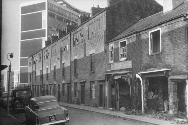
Yes, I think it is Thomas Street but the row on the right is a court between Thomas and Moat. |
| Streets and Roads - Spon Street | |
|
Rob Orland
Historic Coventry |
317 of 513
Sat 16th Dec 2017 5:47pm
I agree - just to the left (north) of Thomas Street would be the river, which continues along to just brush past the south side of the Rudge (later GEC) works, which means the remaining part of Moat Street is just on the right of the photo. This map clarifies it a little. |
| Streets and Roads - Spon Street | |
|
Wearethemods
Aberdeenshire |
318 of 513
Sat 16th Dec 2017 7:04pm
On 16th Dec 2017 5:16pm, NeilsYard said:
Actually the more I look at that photo that I just posted I'm not sure it is Trafalgar Street? Isn't it looking east along Thomas Street with Moat Street to the right?
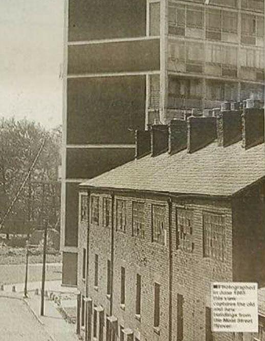
The photo you posted Neil was taken from Givens House (8 storey block) being built about 1959. I would suggest from the 4/5th floorcirca 1966. That is indeed Thomas Street as we moved into a maisonette (Corrie House) on Dec 13th 1965. The bottom part of Thomas Street in the photo was yet to be demolished and the houses and courts and pub were still occupied until 1967/8. There is a photo taken from Thomas Street after the houses etc. above were empty awaiting demolition looking up at Givens House. It might be on this forum somewhere. I have a photo of scooters on Thomas Street with the new Ring Road and the GEC in the background taken from the bottom corner of the picture you posted. I need to check out how to post photos considering I've only been contributing with words for a few years now! |
| Streets and Roads - Spon Street | |
|
NeilsYard
Coventry |
319 of 513
Sat 16th Dec 2017 7:14pm
Love to see that one mods |
| Streets and Roads - Spon Street | |
|
NeilsYard
Coventry |
320 of 513
Sun 17th Dec 2017 6:59pm
I think this is the one you were referring to mods.

|
| Streets and Roads - Spon Street | |
|
Wearethemods
Aberdeenshire |
321 of 513
Mon 18th Dec 2017 10:06am
Yep that's it Neil Thanks, brings back some memories |
| Streets and Roads - Spon Street | |
|
NeilsYard
Coventry |
322 of 513
Mon 18th Dec 2017 10:33am
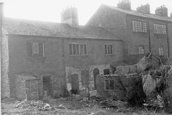
Back of the same properties, mods 
|
| Streets and Roads - Spon Street | |
|
Wearethemods
Aberdeenshire |
323 of 513
Mon 18th Dec 2017 12:22pm
Oh yes Neil. I believe the river would have run at the bottom of those gardens where later the iron bridge from the Sowe I think was installed about 1969. |
| Streets and Roads - Spon Street | |
|
Malvern
Somerset |
324 of 513
Mon 18th Dec 2017 7:14pm
Thanks for alerting me to Real Ale Rambles as this has helped me locate a number of my grandmother's side of the family.
In the 1901 census my grandmother is working for John Henry Bates who at that time is described as a wine merchant but who went on to run The Albany from 1909-1919, whilst in 1911 her two younger brothers and sister were all working for Harrry Hewitt who ran the Old Baths Hotel in Smithford Street from 1909 to 1913. There's a great picture on Real Ale Rambles of Harry Hewitt standing outside his hotel! Malvern
|
| Streets and Roads - Spon Street | |
|
moriarty
allesley park coventry |
325 of 513
Sat 23rd Dec 2017 8:39am
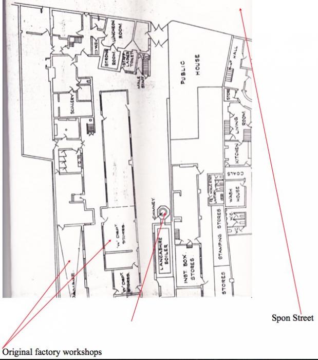
Oops, sorry. On review I'd like to make a correction to post 310.
I now realise the dotted rectangles I thought were the workshop foundations are nowhere near the Rotherham's factory! I based this on the silhouette of the building fronting Spon Street on post 301 which appears similar, I should have checked on a more complete map! Rotherham's should be at number 27 where the arrow and number 226.1 is on post 301. This 1964 ground plan clearly shows the Victorian workshops, although fire damaged, are still standing (thank you Coventry Archives).
On a brighter note I can perhaps identify the tall hex chimney in post 305 it is also on the plan, the camera has compressed the image in post 305 but that looks like the corner of the Windmill to the right. There seems to be just the back wall left of a demolished row of buildings in front of the two storey block in the centre of the photo 305 (called the box stores).
On the plan this building has a chimney stack on the right end wall not on the plan, however the wall has reinforcing on this wall on the plan! There was another chimney shown on earlier engravings of the factory at the end of the Victorian workshops which is not on this plan, this chimney looks to be the original driving engine house for the pulleys in the workshops and would have gone by 1964.
 |
| Streets and Roads - Spon Street | |
| Helen F |
326 of 513
Sun 24th Dec 2017 4:08am
|
|
Helen F
Warrington |
327 of 513
Fri 12th Jan 2018 2:38pm
Sometimes you (by which I mean me) can't see for looking. I've scoured the library pictures over and over again and thought I'd exhausted the images for new clues. Then I'm looking up 'head' for images of the King's Head and up pops Holyhead Road images including one of a shop called Youett's. I've just swept past it before because it wasn't my area, except it's the left hand corner of the road with Spon Street. |
| Streets and Roads - Spon Street | |
|
Midland Red
|
328 of 513
Fri 12th Jan 2018 5:25pm
. . . and what a wonderful photo it is too |
| Streets and Roads - Spon Street | |
|
Helen F
Warrington |
329 of 513
Sat 13th Jan 2018 12:17pm
Indeed it is MR. I note that there are no tram tracks. That would make it a fairly early image. |
| Streets and Roads - Spon Street | |
|
NeilsYard
Coventry |
330 of 513
Sun 14th Jan 2018 3:28pm
To go with the others, Trafalgar Street nearing its end - so the caption says - though it looks like Thomas Street to me.
 |
| Streets and Roads - Spon Street | |
This is your first visit to my website today, thank you!
4,032,786Website & counter by Rob Orland © 2024
Load time: 697ms