|
NeilsYard
Coventry |
16 of 70
Mon 4th Jun 2018 2:56pm
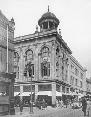
Whilst researching something else - I think these are the same buildings from Anne's clipping above. From BFA in 1931 whilst Corporation Street was going in.

|
| Streets and Roads - Fleet Street | |
|
Prof
Gloucester |
17 of 70
Sun 24th Jun 2018 10:14pm
You can see the cupola on the top of the Co-op on the corner very clearly in Neil's photo also shown in Annewiggy's photo. |
| Streets and Roads - Fleet Street | |
|
NeilsYard
Coventry |
18 of 70
Mon 25th Jun 2018 11:36pm
Rob's got a much better picture of it here, Prof 
|
| Streets and Roads - Fleet Street | |
|
NeilsYard
Coventry |
19 of 70
Tue 26th Jun 2018 3:30am
Just thought this made an interesting comparison - barely a street anymore.

 |
| Streets and Roads - Fleet Street | |
|
Prof
Gloucester |
20 of 70
Mon 24th Sep 2018 8:35pm
This is the same as the1929 (C & W Coll'n) view Helen F

|
| Streets and Roads - Fleet Street | |
|
Prof
Gloucester |
21 of 70
Sun 7th Oct 2018 7:53pm
 |
| Streets and Roads - Fleet Street | |
|
NeilsYard
Coventry |
22 of 70
Sun 21st Oct 2018 10:41am
I'm sure some of you spotted this already but I've only just realised this one from Historic England which shows No's. 5-6 Fleet Street in 1941 . . .
 . . . is the same side of the building in Rob's Library images here (noted by the lovely columned doorway) which was opposite The City Arms and the junction with West Orchard which you can see in the background.

|
| Streets and Roads - Fleet Street | |
|
Helen F
Warrington |
23 of 70
Thu 4th Jul 2019 12:23pm
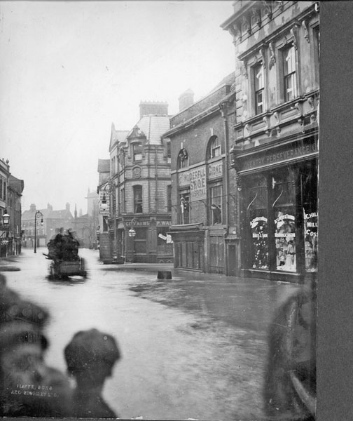
Just a thought - I was wondering if Fleet Street was a misheard 'Flood Street'?

|
| Streets and Roads - Fleet Street | |
|
argon
New Milton |
24 of 70
Thu 4th Jul 2019 1:10pm
Looking at Rob's street maps it looks as if Fleet Street appears some time before 1400 with West Orchard, to meet Spon Gate. It seems to have taken over part of the old Smithford Street, and so may have been named after a nearby feature which would be the river Sherbourne. If the river was fast running there it could be described as fleet. |
| Streets and Roads - Fleet Street | |
|
Kaga simpson
Peacehaven, East Sussex |
25 of 70
Thu 4th Jul 2019 1:32pm
A long time ago that was called Spon brook in deeds and papers. The area was always getting flooded, that's why they built Spon bridge. The word Spon was probably the stretch of ground or span or space between the town and the lepers hospital. Spon bridge wasn't erected till 1767 because of a flood the year before that caused huge damage. Again, on the Sunday 9th Oct 1800 the water rose, trapping the people in St Johns Church in the morning - the last of the congregation was not taken away till 8 o'clock that night. The water was 5/6ft high at the bottom of West Orchard. It even did damage in the Burges. |
| Streets and Roads - Fleet Street | |
|
syetler
Greater Manchester |
26 of 70
Wed 24th Jul 2019 12:04pm
My great grandparents were confectioners and lived at 12 Fleet Street until the early 1900s when they emigrated to Canada. I am looking for a picture of the area. |
| Streets and Roads - Fleet Street | |
|
Helen F
Warrington |
27 of 70
Wed 24th Jul 2019 1:32pm
Hi.
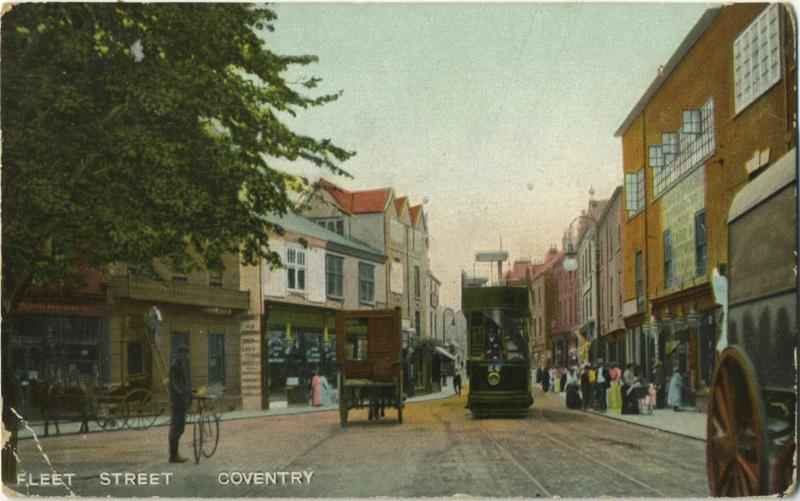
As far as I can tell, number 12 was on the south side of Fleet Street to the east of the passageway leading to court 4. It was the left hand side (and left of the drain pipe) of the 3 storey, red brick building on the right of this picture. You can see the archway into court 4.
 In this postcard you can also see it on the right, the furthest of the orange buildings. Not sure what date this is.
 The building survived the war, so there might be better pictures out there. It appears in Britain From Above in a few places. If you follow the link below it will take you to one example. If you get a login (free) you can zoom in to the area.
A fifth of the way up from the right hand bottom corner
Number 12 at the marker. You'll need to zoom out twice
Once you know where it is, you can select older maps on the left hand side. Zoom in or out to get the best view it will allow.
Hope this helps
 |
| Streets and Roads - Fleet Street | |
|
Kaga simpson
Peacehaven, East Sussex |
28 of 70
Sat 27th Jul 2019 11:40am
Talking of Fleet Street being wet.
At the close of the 18th century, a coach driven by a driver named Marsh coming from Birmingham at great speed turned into Fleet Street. By an unlucky chance, a coal biggler's (dealer) donkey and cart, came abruptly out of West Orchard. Marsh, unable to pull up in time, the horses and coach were overturned causing a great spill. The passengers were shaken and bruised, the four horses getting up dragged the coach some distance before they stopped. Marsh was thrown off the coach into the arms of the landlord of the Ram Inn who happened to be standing at his front door smoking a pipe, and much to the landlord's amazement they both rolled down the steps which led from the front door to the passage, and tumbled into the bar together - neither much hurt except for a few bruises.
I love these old stories. |
| Streets and Roads - Fleet Street | |
|
NeilsYard
Coventry |
29 of 70
Fri 6th Sep 2019 10:03am
Pretty sure we have seen this one before but added due to its clarity - mods move if desired. However I think this shows the backs of properties on Fleet Street looking over to the clearance for Corporation Street in 1926.
I have an idea the photographer may have been standing on the roof of a building, possibly in Conduit Yard?

|
| Streets and Roads - Fleet Street | |
|
Kaga simpson
Peacehaven, East Sussex |
30 of 70
Sat 21st Sep 2019 5:04pm
Helen F,
Your post, on the right, the large house you see before the Precinct, this side of the recess you can just see a little building, this was the Casino Cafe, a temp building. Like all the other buildings it had a limited time, but it did open till 9pm, and was a great meeting place for young people to meet on that side of town. |
| Streets and Roads - Fleet Street | |
Website & counter by Rob Orland © 2024
Load time: 610ms