|
Dreamtime
Perth Western Australia |
16 of 51
Wed 9th Oct 2013 3:49pm
That's another problem solved then MR - Next ? |
| Streets and Roads - Street behind Holy Trinity Church | |
|
gangan
Stockton, Southam |
17 of 51
Sun 13th Oct 2013 3:49pm
On 9th Oct 2013 9:15am, Midland Red said:
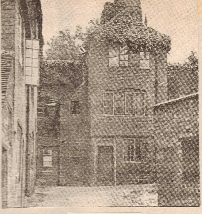
I certainly agree with the above comments - it looks nothing like anywhere in Coventry that I have seen before, and I'm sure that, by now, someone on the forum would have come up with an identification
Not for the first time, Mirrorpix seems to have included an erroneous caption
Hello MR. Just to say it definitely is Hill Top in Coventry |
| Streets and Roads - Street behind Holy Trinity Church | |
|
Midland Red
|
18 of 51
Sun 13th Oct 2013 7:47pm
Hi G - what is definitely Hill Top? |
| Streets and Roads - Street behind Holy Trinity Church | |
|
Midland Red
|
19 of 51
Tue 22nd Oct 2013 8:23am
On 22nd Feb 2013 3:10pm, Annewiggy said:
Here is a picture of Hill Top dated 1950.
I am still struggling to identify the location of this photograph - I cannot see where in Hill Top this photo could have been taken, given the relative location of the spire
Please can somebody help? 
|
| Streets and Roads - Street behind Holy Trinity Church | |
|
Annewiggy
Tamworth |
20 of 51
Tue 22nd Oct 2013 11:06am
Hi Midland Red
The picture is definitely in Coventry as it is in the collection I bought from Mr Beasley. I have just found another copy of it in a little scrapbook he has made from cuttings which are from 1950's Telegraphs. Under this he has written "Hill Top, building shown finally demolished in 1965".
Just looking at some of the pictures on the internet, there are some 3 storey buildings standing. I do not know the area but if you were at the top of Hill Top and turned left a little and faced towards Holy Trinity could that have been where this building is. What is there now? The building showing on the R H corner of the picture appears to have a corrugated iron roof. Internet pictures seem to show, looking up Hill Top, lower outbuilding type buildings on the left. |
| Streets and Roads - Street behind Holy Trinity Church | |
|
Helen F
Warrington |
21 of 51
Tue 22nd Oct 2013 11:38am
To me it looks like a wall at the back of the building, not another building and the ivy isn't obvious in many photos. I'm guessing that it's the other side of the wall to the tennis court/bowling green, but there aren't many pictures of that area to identify exactly.
Constitutional Club
Where the initial picture that started this thread is taken from I've no idea. It doesn't even look like Coventry stonework. |
| Streets and Roads - Street behind Holy Trinity Church | |
|
Annewiggy
Tamworth |
22 of 51
Tue 22nd Oct 2013 12:39pm
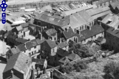
This is a shot from Britain from above taken in 1946. Holy Trinity is just off the bottom right hand corner. There is a building in the centre towards the bottom of the picture that has a hipped roof like the one in the picture rather than a gable and there is also a wall behind it!
 |
| Streets and Roads - Street behind Holy Trinity Church | |
|
Midland Red
|
23 of 51
Tue 22nd Oct 2013 12:42pm
On 22nd Oct 2013 11:06am, Annewiggy said:
Hi Midland Red
The picture is definitely in Coventry as it is in the collection I bought from Mr Beasley. I have just found another copy of it in a little scrapbook he has made from cuttings which are from 1950's Telegraphs. Under this he has written "Hill Top, building shown finally demolished in 1965".
Just looking at some of the pictures on the internet, there are some 3 storey buildings standing. I do not know the area but if you were at the top of Hill Top and turned left a little and faced towards Holy Trinity could that have been where this building is. What is there now? The building showing on the R H corner of the picture appears to have a corrugated iron roof. Internet pictures seem to show, looking up Hill Top, lower outbuilding type buildings on the left.
Hi Anne
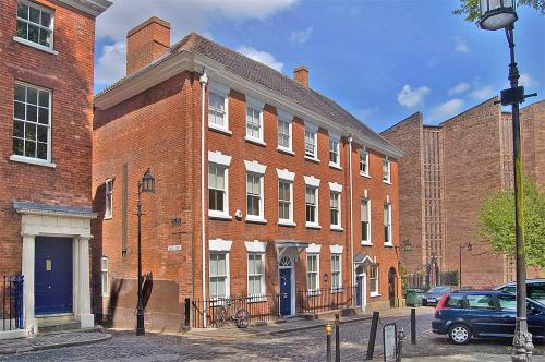
If you stand at the top of Hill Top, with Hill Top behind, Holy Trinity is to the right
Between Holy Trinity and Hill Top is Priory Row, the buildings on which are unchanged for many many years
This photo shows Hill Top viewed from Holy Trinity
 This is the view looking down Hill Top - as I recall it in the '50s it was a steep incline all the way to the bottom, which doesn't reflect in the photo I am querying
|
| Streets and Roads - Street behind Holy Trinity Church | |
|
Midland Red
|
24 of 51
Tue 22nd Oct 2013 12:46pm
On 22nd Oct 2013 11:38am, Helen F said:
To me it looks like a wall at the back of the building, not another building and the ivy isn't obvious in many photos. I'm guessing that it's the other side of the wall to the tennis court/bowling green, but there aren't many pictures of that area to identify exactly.
Constitutional Club
Where the initial picture that started this thread is taken from I've no idea. It doesn't even look like Coventry stonework.
Hi Helen
This view does not show Hill Top, which would be a few doors away to the right of the photo - this is looking straight out of the back of Con Club towards the Hippodrome
I think we have all agreed that the original photo in this thread is probably not of Coventry |
| Streets and Roads - Street behind Holy Trinity Church | |
|
Annewiggy
Tamworth |
25 of 51
Tue 22nd Oct 2013 1:01pm
Another thing I have noted is that in the original queried picture the street is paved but everything else we seem to have come up with behind HT they are cobbled so I think you are right MR it probably isn't Coventry. |
| Streets and Roads - Street behind Holy Trinity Church | |
|
Midland Red
|
26 of 51
Tue 22nd Oct 2013 1:02pm
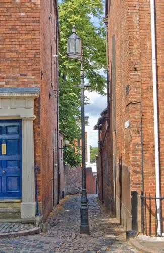
This photo shows a modern view up Hill Top, which retains its original line from the past - you can see how steep it is/was, and to my mind this is the only angle along Hill Top which could possibly give the view of the spire that's in the image under query |
| Streets and Roads - Street behind Holy Trinity Church | |
|
Harrier
Coventry |
27 of 51
Tue 22nd Oct 2013 1:09pm
................... if 00114531 is viewed in Mirrorpix, the word 'behind' becomes 'close' for the same if blurred shot!!!!!!!!! |
| Streets and Roads - Street behind Holy Trinity Church | |
|
Helen F
Warrington |
28 of 51
Tue 22nd Oct 2013 1:21pm
Anne's aerial photo does show something very similar to the photograph. The picture maybe labelled Hilltop so as to be a bit clearer to non locals about the location. It might have been tagged 'old buildings behind New Buildings just before demolition' but that would have been weird. Also does 'Hilltop' just refer to the road or to the area? |
| Streets and Roads - Street behind Holy Trinity Church | |
|
Annewiggy
Tamworth |
29 of 51
Tue 22nd Oct 2013 2:00pm
On an old street map I have Hill Top is a dog leg road leading from the road called New Buildings to Priory Row where it crosses into Hay Lane
|
| Streets and Roads - Street behind Holy Trinity Church | |
|
Helen F
Warrington |
30 of 51
Tue 22nd Oct 2013 2:30pm
  The red marks show the similarities between the two photos. The building coming in at an angle from the right. The three buildings on the left - a small shed like building with a sloping roof; a larger two storey building with a drain pipe between it and the taller building next door. And the building against the wall with the sloping gable. The camera looks from the road New Buildings towards the wall of the Con Club.
I think Anne nailed it.
 |
| Streets and Roads - Street behind Holy Trinity Church | |
Website & counter by Rob Orland © 2024
Load time: 588ms