|
Rob Orland
Historic Coventry |
91 of 129
Fri 15th Jan 2021 10:17am
It's good that you did snap 'em OddSock - as "modern" as they might've seemed a the time, they're our memories now! That's one of my regrets really, that I took virtually no notice of my surroundings and took very few photos, apart from family ones, back then. Easy with hindsight I suppose, but I never guessed back then, while in my late teens/early 20s, that in my 30s (twenty odd years ago), I would suddenly become interested in local history and create a website on something that hadn't even been invented back then called the internet!!! |
| Streets and Roads - Queen Victoria Road (inc Drill Hall) | |
|
NeilsYard
Coventry |
92 of 129
Mon 18th Jan 2021 9:47am
Same for me, Rob! Great photos, OddSock - get the rest of them added! Always thought that Co-op was a bit naff tbh. I don't have the best memories of it anyway as I got caught up in a bit of a drunken brawl waiting outside there for a taxi late 80's when Cov was so friendly on a Saturday night! |
| Streets and Roads - Queen Victoria Road (inc Drill Hall) | |
|
Prof
Gloucester |
93 of 129
Fri 12th Mar 2021 11:13pm
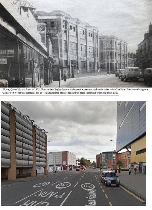
|
| Streets and Roads - Queen Victoria Road (inc Drill Hall) | |
|
Prof
Gloucester |
94 of 129
Thu 16th Dec 2021 11:53pm
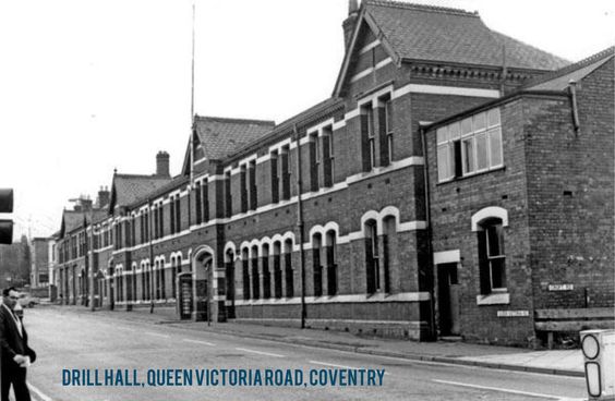
|
| Streets and Roads - Queen Victoria Road (inc Drill Hall) | |
|
Midland Red
|
95 of 129
Sun 26th Dec 2021 3:18pm
Queen Victoria Road, 23 May 2004
Looking from the junction of Croft Road towards St John's Church. The area to the left would soon be demolished as part of the IKEA development.
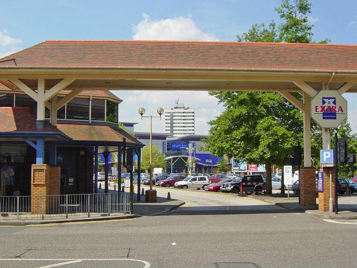
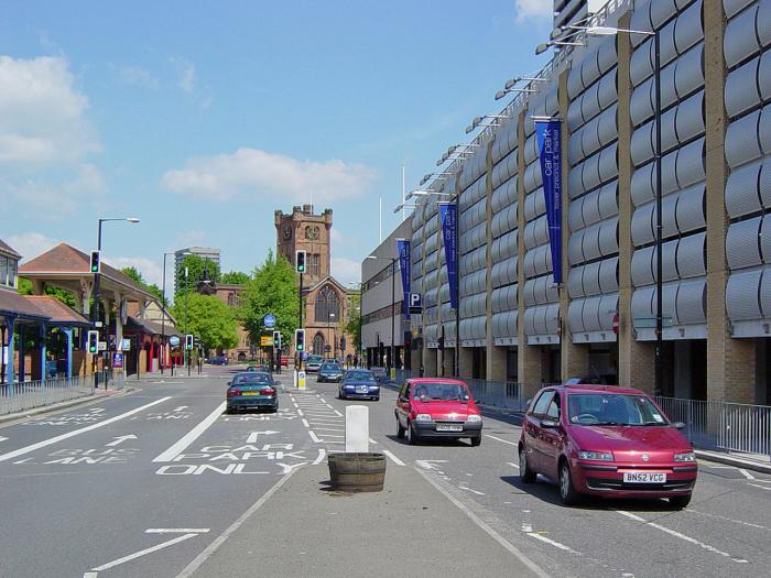 Entrance to Co-op car-park area.
Opened in the mid 1980s, the Co-op supermarket and the surrounding buildings would soon be closed and demolished to make way for IKEA.
|
| Streets and Roads - Queen Victoria Road (inc Drill Hall) | |
|
Annewiggy
Tamworth |
96 of 129
Sun 26th Dec 2021 4:57pm
My mum had volunteered for years at the Myton Hospice shop up there. After it was demolished they moved to Trinity Street and as the ring and ride was not allowed to stop anywhere near, she had to pack in. |
| Streets and Roads - Queen Victoria Road (inc Drill Hall) | |
|
Midland Red
|
97 of 129
Wed 2nd Feb 2022 7:26pm
Thanks to Paul Barlow who has posted on FB this wonderful view (undated) of the bottom part of Queen Victoria Road 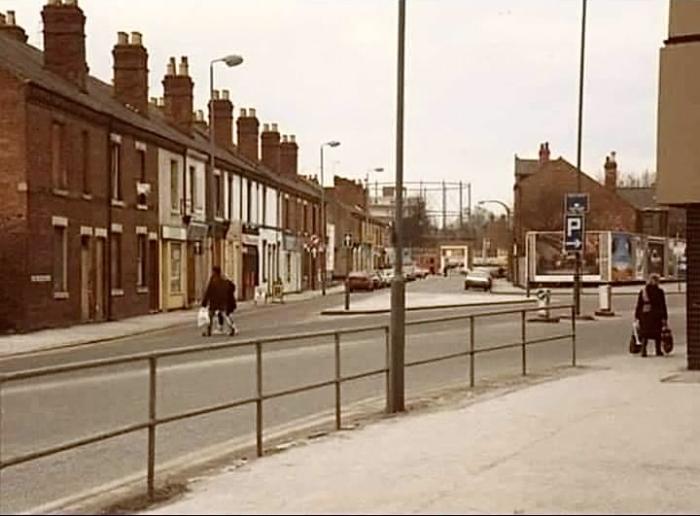
|
| Streets and Roads - Queen Victoria Road (inc Drill Hall) | |
|
NeilsYard
Coventry |
98 of 129
Thu 3rd Feb 2022 9:37am
I think we've had that one before Cliff though I'm still struggling to pin-point the exact spot today? |
| Streets and Roads - Queen Victoria Road (inc Drill Hall) | |
|
Midland Red
|
99 of 129
Thu 3rd Feb 2022 10:09am
X marks the spot, Neil
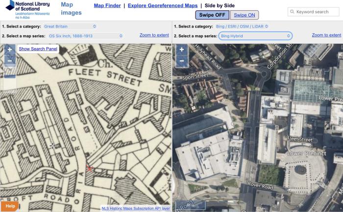
|
| Streets and Roads - Queen Victoria Road (inc Drill Hall) | |
|
Rob Orland
Historic Coventry |
100 of 129
Thu 3rd Feb 2022 10:14am
I think it was taken from around here, Neil - looking towards the Spon Street & Lower Holyhead Road junction in the distance.
The only map of mine I can find that shows that street layout is 1968 on this page. I recall it looking like that in the early 1980s when I worked at the GEC, when the last part of the original line of the northern end of Queen Victoria Road was still there, but not much more than a walk-through to Spon Street, while Corporation Street had been extended south-westwards to form the forked junction that we see in that super photo above. |
| Streets and Roads - Queen Victoria Road (inc Drill Hall) | |
|
OddSock
Coventry |
101 of 129
Thu 3rd Feb 2022 10:47am
Further to Rob's comments I, too, remember this area from the 1980s - I'm sure the houses on the right-hand side (in the photo, that is) were demolished first and, if my memory serves me right, the 'triangle' of land there was levelled and grassed over - I even believe at least three permanent billboard frames were erected on that patch, facing the then C&A store across the road?
OddSock OddSock: Particularly interested in the family surnames Cowley, Shale, & Pratt in Coventry!
|
| Streets and Roads - Queen Victoria Road (inc Drill Hall) | |
|
Helen F
Warrington |
102 of 129
Thu 3rd Feb 2022 11:17am
You can even see the P direction sign for the round carpark. |
| Streets and Roads - Queen Victoria Road (inc Drill Hall) | |
|
NeilsYard
Coventry |
103 of 129
Thu 3rd Feb 2022 3:44pm
Yes, thanks all. I thought it was about there but couldn't correlate the turn in the roads and that island in the middle, from what I recalled, or could see from this one I posted some time ago in this thread. I do remember that line of terraces on the left behind the billboard as my dad often parked on that scrubland car park on the left where you entered from QV Road just before the billboard. What is that building on the very right edge of the photo Cliff added, by where the lady with the heavy shopping bags is walking? Is is that building which C&A were under?
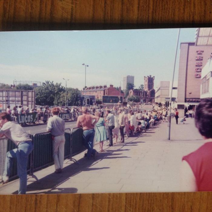 Is the row on Cliff's image the same section on my one above, behind the billboard?
 |
| Streets and Roads - Queen Victoria Road (inc Drill Hall) | |
|
NeilsYard
Coventry |
104 of 129
Thu 3rd Feb 2022 3:54pm
Does this one give us a better clue Rob? That one's a cracker. |
| Streets and Roads - Queen Victoria Road (inc Drill Hall) | |
|
Rob Orland
Historic Coventry |
105 of 129
Thu 3rd Feb 2022 7:25pm
On 3rd Feb 2022 3:54pm, NeilsYard said:
Does this one give us a better clue Rob? That one's a cracker.
Ah yes, that's a great view - I'd forgotten about the aerial shot! The photographer in MR's photo could be standing at the side of of what is now a multi-storey car-park - still Tesco on the last photo you showed us - with the pillar being the thing visible on the far right of the image. |
| Streets and Roads - Queen Victoria Road (inc Drill Hall) | |
Website & counter by Rob Orland © 2024
Load time: 607ms