|
DaveCov
Coventry |
1 of 16
Tue 18th Feb 2025 10:12pm
My grandfather, William Pullen, had a bakery at 18 Tower St before the war which was destroyed in the blitz (Tower St then ran north-south). It was across an alley from the Beehive pub and roughly opposite the Hope & Anchor, but I can't find any photos of that group of streets to show me what the bakery might have looked like or, even better, of the bakery itself. Can anyone point me in the direction of any, please?
Question |
| Streets and Roads - Tower Street | |
|
Garlands Joke Shop
Coventry |
2 of 16
Tue 18th Feb 2025 11:37pm
Hi Dave,
I tried looking on the Britain from Above© Website, couldn't see Tower Street (perhaps another forum member can):
Looked at:
aerial photo 1
aerial photo 2
aerial photo 3
aerial photo 4
You may need to make an account to zoom in.
To be honest, I'm confusing myself now as I can't orient myself in relation to the old pre-war road system. Also, I suspect that Tower Street might just be out of shot
 |
| Streets and Roads - Tower Street | |
|
Helen F
Warrington |
3 of 16
Wed 19th Feb 2025 11:19am
Hi Dave, welcome to the forum
|
| Streets and Roads - Tower Street | |
|
Mike59
Coventry |
4 of 16
Wed 19th Feb 2025 12:11pm
Dave,
If you look at Aerial Image 1, the ref on the bottom margin is EPW053108, you can clearly see Swanswell Pool.
Unless I'm mistaken, the island on Swanswell Pool is located marginally to the west of north, or if you prefer to use the compass points NNW, which deems the image to be looking southwards.
Mike "Yesterday I was a child of the sixties…. Today I’m a cynical adult…"
|
| Streets and Roads - Tower Street | |
|
Garlands Joke Shop
Coventry |
5 of 16
Wed 19th Feb 2025 5:25pm
Well done Helen and Mike, I was getting tied up in knots trying to work out where things were hahahaha
Although now that I've seen Rob's overlay map I wish I'd used that last night now
|
| Streets and Roads - Tower Street | |
|
Garlands Joke Shop
Coventry |
6 of 16
Sat 22nd Feb 2025 12:12am
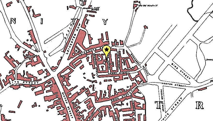
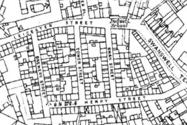
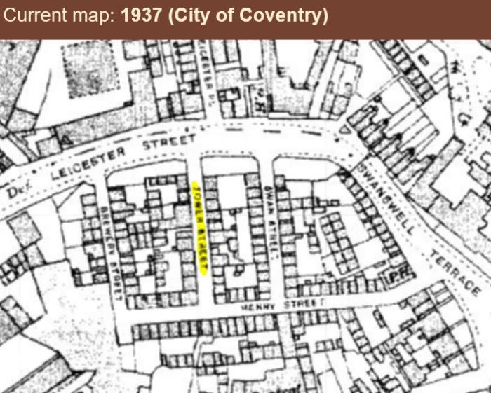
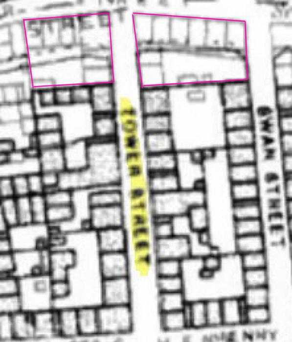
Using Rob's Old maps page you can get a reasonable look at the street plan of Tower Street properties.
1926:
 1937:
1937:
 If you overlay the two maps, there's a large area that appears to have been removed in the decade between the two maps. Assumedly to extend/ widen Leicester Street??? I guess industrialisation meant Victorian Roads were no longer fit for the increased traffic???

|
| Streets and Roads - Tower Street | |
|
PhiliPamInCoventry
Holbrooks |
7 of 16
Sat 22nd Feb 2025 5:30am
Hello
Your contributions to our forum are fabulous Garlands Joke Shop. Over a long period of time. Thank you so much.
|
| Streets and Roads - Tower Street | |
|
Helen F
Warrington |
8 of 16
Sat 22nd Feb 2025 8:42am
On 22nd Feb 2025 12:12am, Garlands Joke Shop said:
If you overlay the two maps, there's a large area that appears to have been removed in the decade between the two maps. Assumedly to extend/ widen Leicester Street??? I guess industrialisation meant Victorian Roads were no longer fit for the increased traffic???
Hi Garlands. I'm sure that widening the roads was a big part of the justification for demolition but the state of the buildings was another. Some of the properties were very small and back to back with other, equally small neighbours. Initially they tried to improve the places by knocking back to backs into one to give the properties a through draught but the basic fabric of the buildings was shocking. This area was one of the first to be built on, once cities with commoner rights were freed from the constrictions. They weren't very different from the properties that had been squeezed into the courts and yards within the boundaries of the old city.
The width of some of the roads was amazing though. Not much wider than the later pavements.
Great map comparison you've done |
| Streets and Roads - Tower Street | |
| Garlands Joke Shop |
9 of 16
Sat 22nd Feb 2025 4:50pm
|
|
Garlands Joke Shop
Coventry |
10 of 16
Fri 7th Mar 2025 5:11pm
DaveCov Just looking on the 1921 census.
A William Isaac Pullen, living at 198 Swan Lane, Coventry and working as a bread maker at 15 Swanswell Street, Coventry. Wife: Ethel May Pullen. Daughter: Ethel M Pullen.
Is this your Grandfather?
|
| Streets and Roads - Tower Street | |
| Helen F |
11 of 16
Fri 7th Mar 2025 5:19pm
|
| Garlands Joke Shop |
12 of 16
Fri 7th Mar 2025 6:34pm
|
|
DaveCov
Coventry Thread starter
|
13 of 16
Wed 12th Mar 2025 3:49pm
On 7th Mar 2025 5:11pm, Garlands Joke Shop said:
Yes, that's him. Ethel M Pullen was my mum, and you're right that in 1921 she's described as 'daughter'. However, she's 'niece' in 1911, so the story is a bit more complicated than I was told as a child! I remember 198 Swan Lane well; it was William & Ethel's home until he died in 1961 and remained hers for another 10 years or so.DaveCov Just looking on the 1921 census.
A William Isaac Pullen, living at 198 Swan Lane, Coventry and working as a bread maker at 15 Swanswell Street, Coventry. Wife: Ethel May Pullen. Daughter: Ethel M Pullen.
Is this your Grandfather?
|
| Streets and Roads - Tower Street | |
|
DaveCov
Coventry Thread starter
|
14 of 16
Wed 12th Mar 2025 3:53pm
On 18th Feb 2025 11:37pm, Garlands Joke Shop said:
Hi Dave,
I tried looking on the Britain from Above© Website, couldn't see Tower Street (perhaps another forum member can):
Looked at:
aerial photo 1
aerial photo 2
aerial photo 3
aerial photo 4
You may need to make an account to zoom in.
To be honest, I'm confusing myself now as I can't orient myself in relation to the old pre-war road system. Also, I suspect that Tower Street might just be out of shot
Thanks for this. That's the right place for the Beehive, just north of the alley giving entrance to a court behind Tower St, on the left as you look at the image. My granddad's bakery was the south side of that alley. at no 18.

|
| Streets and Roads - Tower Street | |
|
DaveCov
Coventry Thread starter
|
15 of 16
Wed 12th Mar 2025 4:14pm
On 19th Feb 2025 11:19am, Helen F said:
Hi Dave, welcome to the forum
Hi Helen
Thanks for this. I see you've found the best picture there seems to be of Tower St (I still hope for better!). This block of streets isn't on Thomas Sharp's 1807 map of Coventry but are shown in the first OS map from 1836, so that dates their construction as best as I've managed so far. Ben Kyneswood is going to contact the Herbert archive for me and we'll see what, if anything, they can turn up, then we'll go and see what we can make of it.
Much of Tower St was listed as "to be demolished" after the Nov 1940 air raid, but neither nos 17 or 18 appear, though nos 6, 7, 14, 15, 16, 19, 21, 22 and the 4 properties in Court 1 - which were on land registered to no 17 - are shown as "to be demolished". No 17 is so described after the April 1941 raid, and I think no 18 is probably included in that listing as it was owned by the same person and had been part of a single freehold (I've seen a note saying that "no 18's documentation was unclear and incomplete, requiring a statutory declaration concerning Charles Walton's ownership by his widow and son"). So the demolition of Tower St was the result of German bombing rather than being slum clearance. |
| Streets and Roads - Tower Street | |
Website & counter by Rob Orland © 2025
Load time: 750ms