dutchman
Spon End
|
31 of 418
Tue 8th Oct 2013 11:32pm
Well done Helen and Neil 
That picture had me foxed for hours! It was also taken a lot later than 1919, could even be as late as 1939 judging by the car and the fashions. The George had closed as a pub by then and appears to be in use as a pawnbrokers?
Here's the same view taken many years earlier when the George Inn was at its peak:
Pictures of Coventry |
|
Streets and Roads -
Little Park Street
|
Dreamtime
Perth Western Australia
|
32 of 418
Wed 9th Oct 2013 3:20am
Love that picture Dutchman, seen it before. I hope they remembered to 'duck' coming out of there !!!!!  |
|
Streets and Roads -
Little Park Street
|
Helen F
Warrington
|
33 of 418
Fri 11th Oct 2013 9:38pm
Ok, bit of a brain teaser. I'm looking to place these buildings on Little Park Street.
The first is Bridgeman's and I know it's on the west side.
Bridgeman's
The second Is on the west and probably south of Cow Lane because you can see what I assume is Greyfriars in the background.
South of Cow Lane
And the last is probably also on the west but I do have gaps in what I can place so it might be on the east.
Image 1
Image 2
I think all three are south of Cow Lane but looking from map to map I can't quite fit them exactly. I've got theories but no facts. Anybody got any great ideas?
|
|
Streets and Roads -
Little Park Street
|
Rob Orland
Historic Coventry
|
34 of 418
Fri 11th Oct 2013 10:38pm
Hi Helen,
Not sure about the last three, but fairly certain about the position of Orlando Bridgeman's place (well, I would, wouldn't I !!  ).
Our son, Steve, has a "now & then" pairing covering that place on his site, but he hasn't yet got around to adding any text to it. Here's where you'll find it.... http://steve.historiccoventry.co.uk/.
To the left of Bridgeman's house appears to be an early Kirby House before a third storey was added. The doorway looks very similar though.
I look forward to learning from anyone else about the other three buildings. |
|
Streets and Roads -
Little Park Street
|
Helen F
Warrington
|
35 of 418
Fri 11th Oct 2013 11:00pm
Thanks Rob. 
I'd first assumed that Kirby House was the building set back but then I thought that there were sufficient differences for it to be a different building. The Castle is also similar and I wondered of there was a rash of building Georgian fronts at one point and there could have been more than two on the same street. If you know for sure then that's great. Between the various versions of old maps there are several possibilities with inset gardens, including Banner House which is a gap on the oldest maps. There was something very big a little over half way to the old gate from Cow Lane.
Two other reasons why I ruled it out were the various drawings of the house.
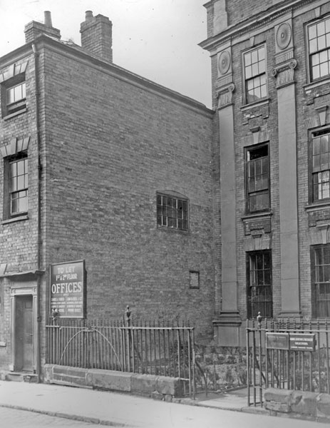
The picture above shows Georgian block work edging on the corner of the building to the left of Bridgeman's and the tall, brick building that stood next to Kirby House in the black and white photos didn't have it. I agree it could have been rebuilt more than once.
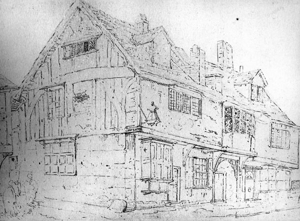
The second reason is from Dr Troughton's drawings. He drew the building to the left of Kirby House as a timbered medieval building.
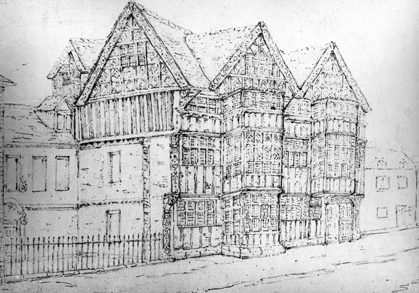
But when he draws Bridgeman's he also draws the taller Georgian building to the left. Now his work varies between contemporary work and copies of earlier pictures so who knows? He died in 1868 and the house was demolished 'early 19th century' so it's possible he did draw it before it was destroyed.
Even studying the fence, it looks different with a stone base on the Kirby house fence and no obvious gate on the Bridgeman's house picture (suggesting the Georgian building was part of a larger structure and the door wasn't used).
I've gone round and round in circles over these house pictures. Not enough pubs on Park Street to peg things down. 
PS Your family is very talented. I've searched your web sites for any clues to street views and they've been invaluable.  |
|
Streets and Roads -
Little Park Street
|
Helen F
Warrington
|
36 of 418
Sat 12th Oct 2013 1:47am
Ok how does this logic hold up?
I think Bridgeman's was in the big gap on the left.
Map of Bridgeman's location?
and I think one of the old pictures gives the clue.
The small building on the far right has 8 windows along the top floor (I zoomed in to count them). At first I thought this was Tudor styling and was frustrated because it looks nothing like Chequers which is what it would have to be to fit the map.
Yet another Picture of Bridgeman's
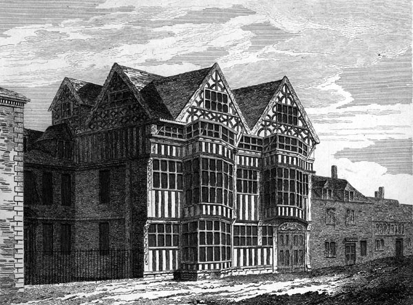
But then I looked closely at the photo of Chequers and I think I can see two windows hidden by the sign in the middle.

What do you think? |
|
Streets and Roads -
Little Park Street
|
dutchman
Spon End
|
37 of 418
Sat 12th Oct 2013 1:58am
Looks convincing to me? 
Artists' engravings should be considered a rough guide only especially where a building being examined is not the main subject of the illustration. |
|
Streets and Roads -
Little Park Street
|
Helen F
Warrington
|
38 of 418
Sat 12th Oct 2013 10:21am

Ok, the next possibility is more of a punt. I think that this series of buildings might be the ones to the right/north of Kirby House. If not, then they have to be right/north of Banner house because there are no other garden gaps along the road in any of the maps (not that means there wasn't a gap between maps).
Possible houses North of Kirby House?
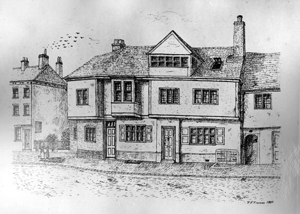
The reason I think they're next to Kirby House is because the house next door is very similar to the tall ugly building on the corner of Cow Lane. Even the funny dark oblong I thought was a window on the end wall could be the sign on the edge of that building. The only obvious difference is the detail under the roof edge which was probably wood and could easily have been changed from when this picture was drawn and when the photo was taken, not long before it was demolished. Again the fence looks very similar in both pictures.
Building South of Kirby House

Possible? |
|
Streets and Roads -
Little Park Street
|
Midland Red
|
39 of 418
Sat 12th Oct 2013 10:29am
There's a definite similarity between those two images - the building "south of Kirby House" looks virtually the same in both, as do the railings in front of Kirby House |
|
Streets and Roads -
Little Park Street
|
Rob Orland
Historic Coventry
|
40 of 418
Sat 12th Oct 2013 10:54pm
Helen, I think your research and reasoning are absolutely spot on. 
A while ago when I asked more knowledgeable people than myself about the location of the Bridgeman house, I was told words along the lines of "it is thought that Kirby House is the one pictured next to it in the Poole illustration". And of course, once I looked again at the old Taunton picture in Benjamin Poole's huge 1870 history book, I noticed the similarity of the style and doorway and agreed.
However, looking carefully at your fine recent research, I have to doubt what I thought I knew - in fact I'm convinced now that you have the location spot on in the centre of that map you linked to above. And one reason more to agree with you is something that Poole said on page 359, right opposite the illustration of the "Ancient house in Little Park Street". He states...
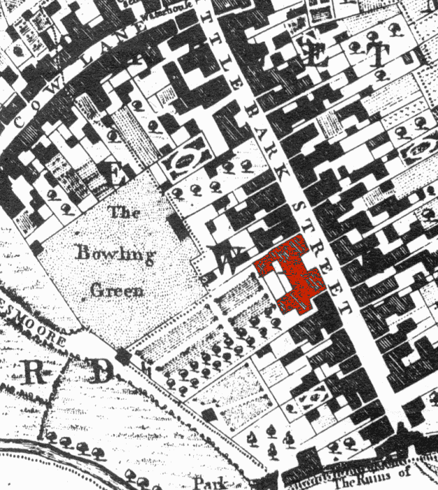
" ...previously occupied by Sir Orlando Bridgeman, and taken down early in the present century. The site of this old house is now enclosed within a brick wall and gates." - which perfectly matches the large gap between houses seen in your map link.
And the other images you linked to, showing the set back Kirby House with the railings next to the brick house with the sign on the wall, give further evidence that this was not the site next to Bridgeman's place.
And now, here's part of the 1749 map, on which I've highlighted where I think that gap was eventually made. I wonder if, in the 1870 drawing, the building set back (that I originally thought was Kirby House) was actually part of the bay-windowed Bridgeman house?
 |
|
Streets and Roads -
Little Park Street
|
Helen F
Warrington
|
41 of 418
Sun 13th Oct 2013 12:17am
 Thanks folks! I've been staring at those pictures for days and only made those connections once I'd asked my initial question.
Rob, I think that at least one point it was all one big building with two Georgian fronted sections because there are no partitions shown on the early maps. Even the very earliest maps show something big there and it was probably all timber framed at one point. Maybe the middle and left hand wings weren't as spectacular or were damaged by fire at some point and rebuilt in the 'new' style? Or maybe it wasn't all one building and different owners treated it differently. There were a lot of big houses, bigger than Kirby House or the Castle and some of them at least must have been similarly decorated to Bridgeman's. At one point that road must have looked amazing.
I still haven't worked out where the third group of houses were other than they must have been on the west side and near the end of Little Park Street or otherwise Greyfriars steeple wouldn't be at that position in the painting. I can't seem to match the combination of buildings and doors. There seem too many passage ways in most of the building blocks while the picture doesn't seem to have any.
|
|
Streets and Roads -
Little Park Street
|
Annewiggy
Tamworth
|
42 of 418
Sun 13th Oct 2013 11:41am
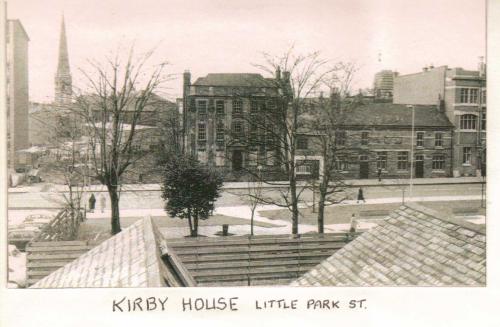
Hi Helen, Did not know if this view would be any help. Don't know the date but must be at least 1960s as there is a block of flats in the background
 |
|
Streets and Roads -
Little Park Street
|
Helen F
Warrington
|
43 of 418
Sun 13th Oct 2013 1:27pm
Thanks Anne 
yes, every picture helps, often the most uninteresting ones tell me stuff I didn't know. Aerial photos in particular can help place buildings and their neighbours, even though they don't show much detail.
This one tells me the proportions of the later buildings so that I can compare them with earlier versions and get the sizes right. Since it's square on to Kirby house It helps a lot. Even tells me the slope of the road. The picture also shows the building next door but one, which I pick up in another photograph and I can compare the shape of the windows and confirm which is the next building in the sequence.
It also confirms my theory that the mystery picture can't be near that and of the road. |
|
Streets and Roads -
Little Park Street
|
Annewiggy
Tamworth
|
44 of 418
Wed 16th Oct 2013 3:59pm
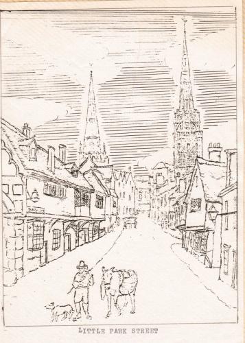
I have just gone through my box of Coventry goodies again and looked at a spiral binder which has some sketches in it and I came across this. I think that maybe someone has copied Troughton's sketches. If that is the case the originals would have been done in the late 19th century and according to Mary Dormer Harris's book about Troughton's sketches "The Bridgeman's House in Little Park Street must have been the most beautiful dwelling of seventeenth century Coventry but its splendid gabled frontage with window-bays two storeys high, with decorated barge-boards and corner posts is gone. Its owners - for no good and sufficient reason it appears - ordered its demolition somewhere in the dark ages, about the beginning of the 19th century."
 |
|
Streets and Roads -
Little Park Street
|
Helen F
Warrington
|
45 of 418
Wed 16th Oct 2013 8:04pm
I was just working up to a comment that I was missing a picture of the building between the George Inn and the Umbrella and you go and post one before I can ask  Thanks Anne.
It does look like a Dr Troughton sketch and it nicely shows the house on the corner of Cow Lane, the mystery buildings next to Kirby House and you can just see the bank at the top of the road. |
|
Streets and Roads -
Little Park Street
|
 That picture had me foxed for hours! It was also taken a lot later than 1919, could even be as late as 1939 judging by the car and the fashions. The George had closed as a pub by then and appears to be in use as a pawnbrokers?
Here's the same view taken many years earlier when the George Inn was at its peak:
Pictures of Coventry

![First page [or press the "F" key] First page](../resource/colour_tint_inc.php?img_file=left-arrow-end.png&clr=AA5511)
![Previous page [or press the "Left arrow" key] Previous page](../resource/colour_tint_inc.php?img_file=left-arrow.png&clr=AA5511)
![Next page [or press the "Right arrow" key] Next page](../resource/colour_tint_inc.php?img_file=right-arrow.png&clr=AA5511)
![Last page [or press the "L" key] Last page](../resource/colour_tint_inc.php?img_file=right-arrow-end.png&clr=AA5511)
 The second reason is from Dr Troughton's drawings. He drew the building to the left of Kirby House as a timbered medieval building.
 But when he draws Bridgeman's he also draws the taller Georgian building to the left. Now his work varies between contemporary work and copies of earlier pictures so who knows? He died in 1868 and the house was demolished 'early 19th century' so it's possible he did draw it before it was destroyed.
 Even studying the fence, it looks different with a stone base on the Kirby house fence and no obvious gate on the Bridgeman's house picture (suggesting the Georgian building was part of a larger structure and the door wasn't used).
I've gone round and round in circles over these house pictures. Not enough pubs on Park Street to peg things down.
  But then I looked closely at the photo of Chequers and I think I can see two windows hidden by the sign in the middle.
 What do you think?
 The reason I think they're next to Kirby House is because the house next door is very similar to the tall ugly building on the corner of Cow Lane. Even the funny dark oblong I thought was a window on the end wall could be the sign on the edge of that building. The only obvious difference is the detail under the roof edge which was probably wood and could easily have been changed from when this picture was drawn and when the photo was taken, not long before it was demolished. Again the fence looks very similar in both pictures.
Building South of Kirby House


