Kaga simpson
Peacehaven, East Sussex
|
61 of 129
Sat 5th Sep 2020 2:44pm
Sorry, Argon, that wasn't my area, but when this forum first started there was a member that used to talk a lot from that area - a long shot, but any topic that deals with that area you could give it a try. |
|
Streets and Roads -
Queen Victoria Road (inc Drill Hall)
|
argon
New Milton
|
62 of 129
Sat 5th Sep 2020 3:18pm
Thank you for your answer Kaga |
|
Streets and Roads -
Queen Victoria Road (inc Drill Hall)
|
heathite
Coventry
|
63 of 129
Sat 5th Sep 2020 3:42pm
Hi all.
A quick look at the 1939 register shows Richard S MEDDOWS & Lucy MEDDOWS at 45 Queen Victoria Road. He is a baker and confectioner, born 1873.
In the 1911 directory for Victoria Terrace (at number 7), which is inside Queen Victoria Road, there is a Richard S MEDDOWS. He is listed as a 'baker' etc.
In the 1935 directory R S MEADOWS is at number 45 Queen Victoria Road, listed as 'dining rooms'.
In 1957 Lucy MEDDOWS (born 1878) is at 45 Queen Victoria Road.
There was a John Stean MEDDOWS on the Walsgrave Road in 1911. It doesn't list a number but gives a house name "Encliffe". On the alphabetic names list he is a baker. It was on the right hand side after Kingsway and before number 52. Just before number 52 was St. Margaret's Church.
 |
|
Streets and Roads -
Queen Victoria Road (inc Drill Hall)
|
argon
New Milton
|
64 of 129
Sat 5th Sep 2020 3:55pm
Thank you, Heathite. 45 Queen Victoria Road will be the one. I remember the bread ovens at the back and thought that there was some seating at the front. |
|
Streets and Roads -
Queen Victoria Road (inc Drill Hall)
|
Prof
Gloucester
|
65 of 129
Mon 7th Sep 2020 10:31am
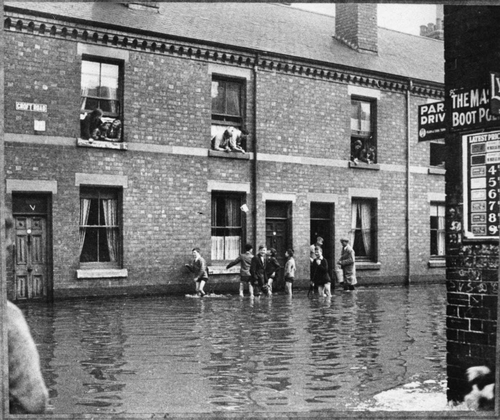
Croft Road seen from Rudge Road.

|
|
Streets and Roads -
Queen Victoria Road (inc Drill Hall)
|
NeilsYard
Coventry
|
66 of 129
Mon 7th Sep 2020 11:43am
Was that your relations' shop, AnneW? |
|
Streets and Roads -
Queen Victoria Road (inc Drill Hall)
|
Annewiggy
Tamworth
|
67 of 129
Mon 7th Sep 2020 6:37pm
I think it is Neil, I have seen this picture before and decided it was then. It was definitely on the corner. Pity you can't see the house numbers opposite. What sort of date do you think that picture is? My great grandmother died in 1920, I think she was still there then.
There is a map on the Starley Road topic which shows the house opposite to be on a corner. As the street sign for Croft Road is on the house on the left I think this must be an end house. |
|
Streets and Roads -
Queen Victoria Road (inc Drill Hall)
|
JRL
Binley Woods
|
68 of 129
Mon 7th Sep 2020 9:23pm
Brilliant photograph. I assume this was taken on the 1st January 1901 when the Sherbourne flooded. My grandparents lived there at number 19 at the time. I also wish we could see the house numbers. They later moved out to Bedford Street. The Coventry Times published a group of photos of the floods at the time. I have copies and I think they appear somewhere on the Forum. |
|
Streets and Roads -
Queen Victoria Road (inc Drill Hall)
|
Helen F
Warrington
|
69 of 129
Mon 7th Sep 2020 10:02pm
Either the end of the road in the picture isn't Queen Victoria Road or it isn't the Yardley shop. That's at the Rudge Road end. |
|
Streets and Roads -
Queen Victoria Road (inc Drill Hall)
|
Prof
Gloucester
|
70 of 129
Mon 7th Sep 2020 10:06pm
Helen, no place to put Rudge Road, nearest I could find. |
|
Streets and Roads -
Queen Victoria Road (inc Drill Hall)
|
Helen F
Warrington
|
71 of 129
Mon 7th Sep 2020 10:10pm
Ah, I see Prof. In that case it is the Rudge Road end and it is the Yardley shop. The other end of Croft Road doesn't fit. 
I can see why the area flooded. |
|
Streets and Roads -
Queen Victoria Road (inc Drill Hall)
|
Prof
Gloucester
|
72 of 129
Mon 7th Sep 2020 11:16pm
|
|
Streets and Roads -
Queen Victoria Road (inc Drill Hall)
|
Prof
Gloucester
|
73 of 129
Tue 8th Sep 2020 7:55am
Helen, JRL seems to confirm? |
|
Streets and Roads -
Queen Victoria Road (inc Drill Hall)
|
Helen F
Warrington
|
74 of 129
Tue 8th Sep 2020 9:00am
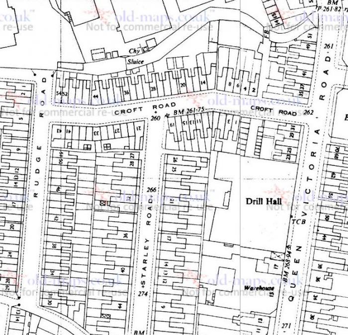
Referencing Heathite's directory snippets on the Yardley Family topic, JRL's relatives were on the north east corner of Starley Road with Croft Road. Not visible in the photo unfortunately. The kids paddling are brave if it's January but everyone was tougher in those days.
Edited because Neil's map gets the other side of the road right.  |
|
Streets and Roads -
Queen Victoria Road (inc Drill Hall)
|
NeilsYard
Coventry
|
75 of 129
Tue 8th Sep 2020 9:34am
Does this help, Anne? It's a circa 1950 map but the numbers would've remained the same.

|
|
Streets and Roads -
Queen Victoria Road (inc Drill Hall)
|