|
Annewiggy
Tamworth |
61 of 145
Mon 17th Sep 2018 11:13am
I am getting confused here as to the original question 
|
| Streets and Roads - Palmer Lane | |
|
heathite
Coventry |
62 of 145
Mon 17th Sep 2018 11:20am
On 17th Sep 2018 11:05am, Kaga simpson said:
Heathite,
No, I wasn't thinking of any particular item, just being a little sarcastic because no-one came up with an answer. It's one of those things where you don't know something and you feel you should and it just drives you mad. And I cannot find out for myself, that's more annoying.
P.S. Heathite, I hate talking to someone I know nothing about, like male or female, district, etc. Ignore this if you need privacy. Regards, Kaga.
Hello Kaga. No, I don't need to be private but the forum dictates what we may post in a post. I'll mail you a potted history of my 'sentence' in Coventry. Look in your email later.
|
| Streets and Roads - Palmer Lane | |
|
Helen F
Warrington |
63 of 145
Mon 17th Sep 2018 11:30am
 Heathite's photo is looking through number 30. The Forbidden Planet is 31. Essentially the ground floor front and back of the building has gone and what is left is now a tunnel. I don't know what the dates of the sides are but they're the supporting walls for 29 and 31. 30 shared them so the front could have been anything from brick infill to lath and plaster to glass and knotty pine. I've posted a conservation report about the Burges somewhere, it will have details about what this gap is. I'll try and find it.
|
| Streets and Roads - Palmer Lane | |
|
heathite
Coventry |
64 of 145
Mon 17th Sep 2018 2:38pm
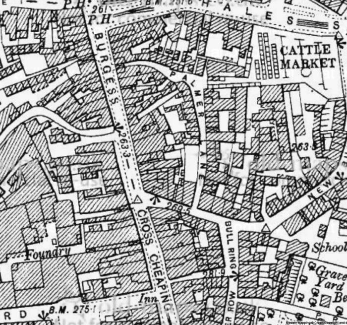
Re: I am not sure where the Burges finishes and Cross Cheaping begins.
I think this 1909 map defines it a bit clearer Ann, what say you?
|
| Streets and Roads - Palmer Lane | |
|
Annewiggy
Tamworth |
65 of 145
Mon 17th Sep 2018 5:10pm
That makes more sense Heathite, Cross Cheaping starting at the junction rather than before as on the earlier map. |
| Streets and Roads - Palmer Lane | |
|
Annewiggy
Tamworth |
66 of 145
Mon 17th Sep 2018 6:57pm
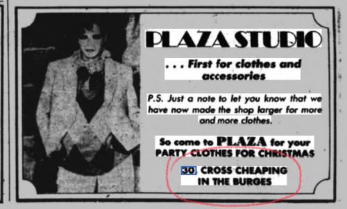
Even more confused now. Have just found this site, Democratic Services, which says the property in question is 30 Cross Cheaping. If you look on page 52 it says "possible original alley" which would make sense, it is what it looks like. |
| Streets and Roads - Palmer Lane | |
|
Kaga simpson
Peacehaven, East Sussex |
67 of 145
Mon 17th Sep 2018 7:06pm
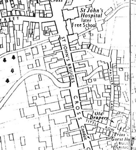
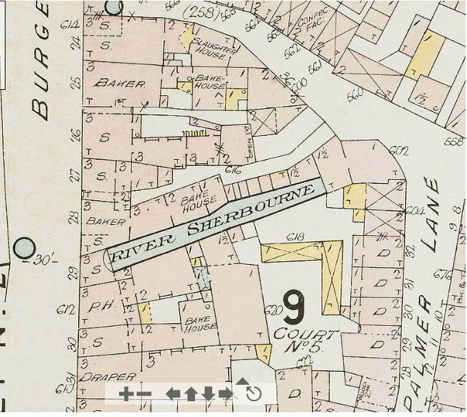
Yes one can get confused. To me, Helen's map is about two hundred years before the map Heathite posted. And look at the changes, for a start Palmer Lane, both entrances were normal lane openings, no tunnels. As I posted before, top entrance was in the middle of Ironmonger Row and not as Heathite routed back into Cross cheaping. Ironmonger Row was swallowed up by Owen Owen in 1936.
The entrance into the Burges from Palmer's, opposite was a large photographer's I believe. As Helen says, No. 30, the ground floor front and back is gone and now a tunnel, when did it go? Or is that it in the back garden and Heathite's picture on post 30.
Yes the Sherbourne ran under Palmer Lane splitting it into underground so as I posted blood and gore ran into the Sherbourne. |
| Streets and Roads - Palmer Lane | |
|
Annewiggy
Tamworth |
68 of 145
Mon 17th Sep 2018 8:30pm
Even they were confused !
|
| Streets and Roads - Palmer Lane | |
|
Prof
Gloucester |
69 of 145
Fri 5th Oct 2018 10:21am
On 13th Sep 2018 7:56am, heathite said:
Kaga -
Here's an image of the Burges showing where Palmer Lane routed.
Regarding the cattle pens, Plaza Studio's entrance looks just the right size for cattle pens to be placed and then opened into.
If you could recall for us the size of a normal shop front opening in the Burges then we could surmise the thinking behind the construction of those small openings.
As you say, cattle were a major part of the daily life, so the traders would have asked for the necessary facilities to be available. The two entrances, Palmer Lane with the bollard in the middle and Plaza Studio, now a shop front, could have been major 'gates' for getting cattle to the rear of the Burges.
This would make your recollections accurate (not that I'm doubting you) so it confirms the major activity and trade in that old part of town.
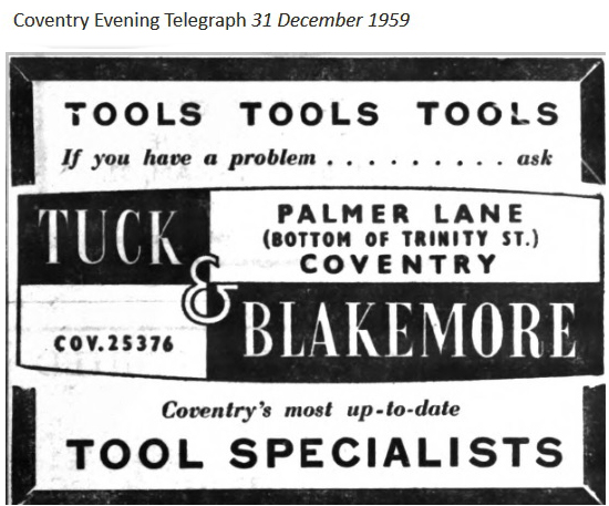
What was the name of the red brick 5 sided building in Palmer Lane at top of picture? I think it used to be a builders' merchants, or ironmongers only I forget the name. Not part of Matterson's I would say.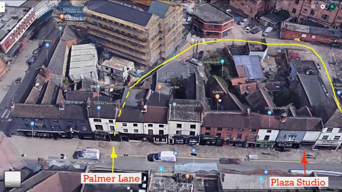 I hope the aerial map makes it easier to cast your mind back.
|
| Streets and Roads - Palmer Lane | |
|
heathite
Coventry |
70 of 145
Fri 5th Oct 2018 11:31am
Hi Prof, could it have been Tuck & Blakemore?
Others are more qualified to answer than me.
Here's an image to consider.
 |
| Streets and Roads - Palmer Lane | |
|
Annewiggy
Tamworth |
71 of 145
Fri 5th Oct 2018 12:02pm
I think it may be this one Prof, discussed in another topic "What is this building?" |
| Streets and Roads - Palmer Lane | |
|
Prof
Gloucester |
72 of 145
Fri 5th Oct 2018 5:30pm
Quite right Heathite and Annewiggy, I remember it as soon as I saw the name in front of me! |
| Streets and Roads - Palmer Lane | |
|
Kaga simpson
Peacehaven, East Sussex |
73 of 145
Thu 11th Oct 2018 9:23am
Now we know there was a man had a shop in Cross Cheaping who was also a stage coach owner, 200 years ago, so he would need stables for fresh horses, close to, and Palmer Lane, and what Heathite found seem to fit the bill. So I can't understand why there has been no attempt or word of someone trying to find out more, like for the sake of a pint and a little time asking the owner of the Cross how it got there, what it is, etc. Palmer Lane and area is one of the most historic places in Coventry, no-one seems to ask when the entrance to the street was closed to the little alley way they are now, where and when was the Bull post got rid of, and a score of questions I would be asking if I was a Coventry resident ? |
| Streets and Roads - Palmer Lane | |
|
Helen F
Warrington |
74 of 145
Sun 14th Oct 2018 5:18pm
The problem is multi-fold Kaga. Possibly the owner of the Cross knows the history of the building but probably they don't. Deeds weren't like today where details about the buildings with little sketches are routinely included. The maps of entry ways are unreliable before 1850. It's hard to marry up the 1807 map with the 1850 one because the former was more of a sketch. It's also not the sort of area that has been in the same family for generations.
When buildings were half timbered, the difference between a passageway and a room was the lath and plaster walls at either end. Earlier still there were few entryways or roads to the back. People just took stuff through their wide front and back doors, across their dirt or stone floors. Most the entries into the yards were originally part of someone's main room. Buildings have been broken up to form shops, re-joined, infilled with brick, knocked down and replaced with a brick edifice. It was a lot more piecemeal than redevelopment is now. Pubs have popped up and then vanished only to reappear. They moved, probably while a building was being knocked about. Pubs didn't need a lot of equipment so it wasn't that hard. Knowing the history of any stretch of the city is a very complicated question.
The people of Coventry mostly don't know the answers to your questions. Many are newcomers, others just aren't interested. The records have often been destroyed and if they haven't they're difficult to read, let alone decipher. The shape of the area where the bull post was sited was changed in the early 1800s but there are no sketches of anything resembling a post or a ring even before that.
The east side of Palmer Lane was demolished to make way for Trinity Street. The west side had already been modified but would still have looked old to our eyes. The picture below shows the south west end corner of Palmer Lane on the right of the photo.
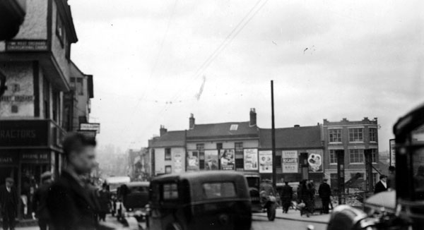 This picture is looking north towards what was left of Ironmonger Row, the end of Palmer Lane and Cross Cheaping before the war. Owen Owens is being built on the right. The building on the corner of Cross Cheaping is NOT the one we know of as the Forbidden Planet. By 1939 they'd finished Owen Owens and built the shops along the west side of Trinity Street, thus reforming the Palmer Lane east side at the same time. The funny 5 sided building dates to this point.
All the buildings in the photo were destroyed by the Blitz along with Owen Owens. A few temporary shops replaced them for a while. The last remaining building on Cross Cheaping was the one that still stands today (one time Forbidden Planet).
View showing aftermath of war on Palmer Lane.
At some point after 1953 new buildings were erected over Ironmongers road, fronting the surviving building on Trinity Street and running back along Cross Cheaping almost as far as the Forbidden Planet building. A small road was constructed there and called Palmer Lane. The modern Ironmonger Row runs over what was the north end of the pre war Owen Owen's.
Complicated much?
 |
| Streets and Roads - Palmer Lane | |
|
Kaga simpson
Peacehaven, East Sussex |
75 of 145
Mon 15th Oct 2018 6:09pm
Good god Helen, I didn't mean ask to see deeds, likely to get a black eye. To me the photo Heathite took of the object out back of the pub, looks to me as if it's only been there a few years, so why didn't he break it up? And where or what position did it come from, and then I would want to go and look at it for tell-tale signs of what it once held. Once I knew that, then I would think of my next move.
But what a find if it was over 200 yrs old. The end of the building on the right was the end of Palmer Lane as it came out into Ironmonger Row. On the right would have been 'The Travellers Rest' on the other corner, a long time ago, have no idea what it was in '36.
The Forbidden Planet has no interest for me, but what was there 200 years ago would.
Helen, firemen walked me through that area, scene of the blitz, just ten years after their experience, it was most detailed and horrific. That area claimed the most firemen killed in one spot during the night. |
| Streets and Roads - Palmer Lane | |
Website & counter by Rob Orland © 2024
Load time: 761ms