|
NeilsYard
Coventry |
31 of 145
Tue 11th Sep 2018 12:03pm
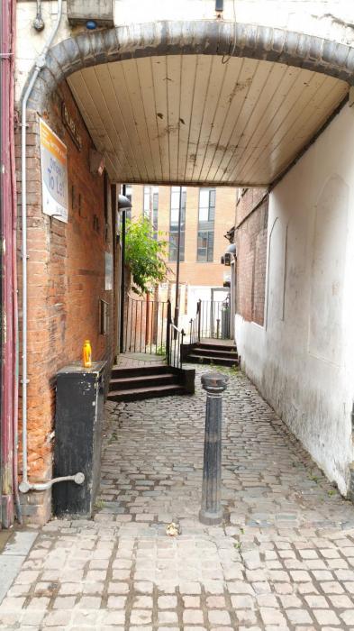
Somewhere around the back of Palmer Lane? |
| Streets and Roads - Palmer Lane | |
|
heathite
Coventry |
32 of 145
Tue 11th Sep 2018 12:34pm
Near enough Neil.
It's behind the builders sheeting covering Plaza Studio.
You get the biscuit |
| Streets and Roads - Palmer Lane | |
|
NeilsYard
Coventry |
33 of 145
Tue 11th Sep 2018 12:52pm
I recognised those fire escape black staircases in the background. |
| Streets and Roads - Palmer Lane | |
|
Kaga simpson
Peacehaven, East Sussex |
34 of 145
Tue 11th Sep 2018 3:07pm
Heathite.
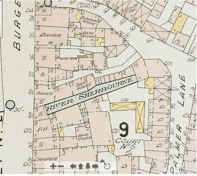
Just were does that photo fit in on an old map, those gates and cellar fit in to an old Butcher Row cellar that housed an animal ready for slaughter? Could that be or is it more modern? |
| Streets and Roads - Palmer Lane | |
|
NeilsYard
Coventry |
35 of 145
Tue 11th Sep 2018 3:29pm
The 1897 Board of Health Map does show a slaughterhouse but further north, nearer the Sherbourne.

|
| Streets and Roads - Palmer Lane | |
|
heathite
Coventry |
36 of 145
Tue 11th Sep 2018 3:36pm
Thank you both for the input.
The photo was taken in between the chipboard 6x4 feet sheets that are now covering the fascia of Plaza Studio, on the right of Coventry Cross in the image.
Kaga, you are the resident 'living library' on this site. |
| Streets and Roads - Palmer Lane | |
|
Kaga simpson
Peacehaven, East Sussex |
37 of 145
Tue 11th Sep 2018 4:02pm
NeilsYard,
Most of those houses were built early 19th century including Butcher Row and Palmer Lane, and killed cattle as well as the slaughter houses. I'm not up on maps and have no idea what those 2/3 mean, but I know there were cellars to most buildings having various uses. When our friends say they have visited Palmer Lane and there is only rubble I wonder if they looked for manhole covers etc for I believe there is still a lot hidden of Coventry's past. We haven't talked about the plague yet, or the suicide of the cathedral tower, or the monks and friars. |
| Streets and Roads - Palmer Lane | |
|
Kaga simpson
Peacehaven, East Sussex |
38 of 145
Tue 11th Sep 2018 4:21pm
Heathite,
We are writing at the same time. I was an inquisitive kid and poked my nose in places I shouldn't have done. I believe under that rubble in your photo there would be a drain, right behind that building I also believe was the Palmer Lane washroom - blood and soapsuds would run into the Sherbourne, and rats as big as dogs. I could have done with this forum 50 years ago, when no one else was asking. We would have found all these answers. |
| Streets and Roads - Palmer Lane | |
|
Kaga simpson
Peacehaven, East Sussex |
39 of 145
Wed 12th Sep 2018 7:33am
Heathite,
A cattle pen, lifted out, turned around and dumped - backside was to the Burges, the gates of the pen into the centre of Palmer Lane. There would be several the same in the Burges and several in Palmer Lane so the cattle would have a central path. |
| Streets and Roads - Palmer Lane | |
|
Kaga simpson
Peacehaven, East Sussex |
40 of 145
Wed 12th Sep 2018 8:45am
Heathite,
I cannot tell from that picture if it's embedded in the ground or how far it is behind the building or if they're wooden struts. I first thought they were iron gates, now I'm not sure? The above was my first thought. |
| Streets and Roads - Palmer Lane | |
|
heathite
Coventry |
41 of 145
Wed 12th Sep 2018 8:56am
Kaga, that image of the frontage to Plaza Studio shows a latticed (criss cross) security grill.
It has been there since at least 2008 according to Google street view.
Today it has a chipboard frontage to restrict access whilst building work is going on.
This is a useful link showing the premises in Burges, note the map selected on the right hand side in the drop down list. |
| Streets and Roads - Palmer Lane | |
|
Kaga simpson
Peacehaven, East Sussex |
42 of 145
Wed 12th Sep 2018 10:08am
Heathite,
Sorry I can't follow all that map stuff, what I'm trying to work out, what it actually is and where was it in 1936 when Palmer Lane was completely left alone while the council tore other streets down. I mean the Burges was the main route north out of the city but they left it alone as well and no one has come up with the answer.
Ok, suppose Palmer Lane and the back of the Burges held deep cattle pens made of steel under the buildings that made the council by pass them and build Trinity Street, who would know?
Now to me, looking back 300/400 years Coventry had a large cattle market, now the Sherbourne ran all round the west and north of the city, so they drove the cattle round the river and came south and east, they penned the cattle in Cow Lane and Bull Yard, then drove them in lots into Smithford market, sold and bought the ones for slaughter they then drove into Cross Cheaping, funnelled them into Palmer Lane, penned them again until wanted in the slaughter house, bottom of Palmer Lane. Almost a straight conveyor belt of its day. I can't see any other better way they could have done it, but I'd love to hear your suggestions and comments.
Kaga. |
| Streets and Roads - Palmer Lane | |
|
heathite
Coventry |
43 of 145
Wed 12th Sep 2018 10:36am
I'll post this for now, and think about what you say. |
| Streets and Roads - Palmer Lane | |
|
Midland Red
|
44 of 145
Wed 12th Sep 2018 11:28am
On 12th Sep 2018 10:36am, heathite said:
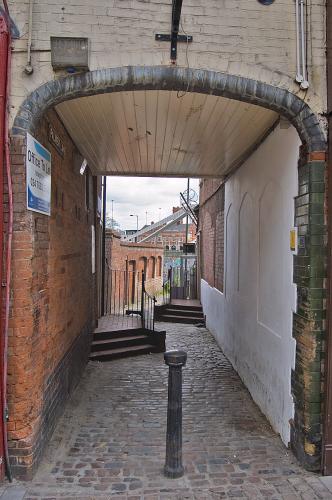
In 2010, one could see the arch and the fire station from there! 

|
| Streets and Roads - Palmer Lane | |
|
scrutiny
coventry |
45 of 145
Wed 12th Sep 2018 12:23pm
In 1966 you could drive a Ford "Pop" through there (just). |
| Streets and Roads - Palmer Lane | |
Website & counter by Rob Orland © 2024
Load time: 621ms