|
deanocity3
keresley |
31 of 129
Tue 17th Dec 2013 8:42am
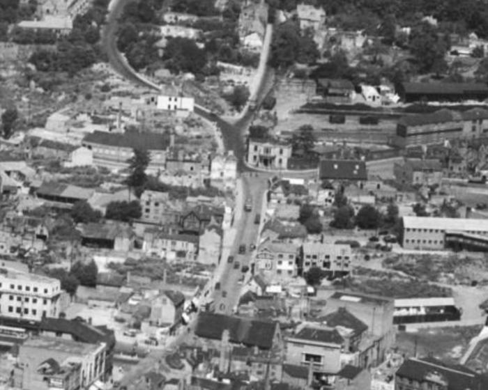
Bishop Street 1947. Old Grammar School at the bottom, Canal Basin top right
 |
| Streets and Roads - Bishop Street | |
|
woodford
coventry |
32 of 129
Tue 17th Dec 2013 10:09am
On 17th Dec 2013 12:05am, Tim Hamer said:
I know it closed, I'm surprised it's been converted into offices, I thought it would have been flats. I'm still confused about the whereabouts of King Street, Could it have been where the footpath is today down the side of Machine Mart, to Upper Well street ?
Oh sorry - you didn't make it clear that you knew. It might be flats, I'll look more closely next time |
| Streets and Roads - Bishop Street | |
|
Annewiggy
Tamworth |
33 of 129
Tue 17th Dec 2013 10:45am
On google maps its still shown as boarded up. It looks as if planning permission was granted for flats at the end of 2012 |
| Streets and Roads - Bishop Street | |
|
Tim Hamer
Coventry |
34 of 129
Tue 17th Dec 2013 1:31pm
Have I got it right this time? Was Bishop Street part of a crossroads with the original Radford Road and King Street,. Up Bishop Street through the crossroads onto Radford Road. And what is Radford Road as we know it today, by the side of the fire station is a new section. THamer
|
| Streets and Roads - Bishop Street | |
|
dutchman
Spon End |
35 of 129
Tue 17th Dec 2013 2:37pm
Almost, the junction was with St Nicholas Street, Radford Road beginning a little further up.
See this map elsewhere on the site which shows where Radford Road began:
1951 street map
|
| Streets and Roads - Bishop Street | |
|
Greenman
Cumbria |
36 of 129
Tue 17th Dec 2013 3:53pm
On 17th Dec 2013 8:42am, deanocity3 said:
Bishop Street 1947. Old Grammar School at the bottom, Canal Basin top right
The two-storey building that is just falling off the right-hand side of the picture, a little less than half-way up, belonged to the Co-op. The ground floor was used as a garage for their vans and lorries, while the second floor, which was reached by the ramp that can be seen running up the side of the building, once provided stabling for the horses that pulled the delivery wagons.
Towards the end of the 1950s, the top floor was given to the Wheatsheaf Players. We stripped out the stalls and a Co-op team converted it into a scenery and costume store, a set-building area and a very cosy rehearsal room.
The Wheatsheaf were still using it in 1968 when I left them, and presumably stayed there until they moved into their current home in Watersmeet Road. I have very fond memories of the place, the people I met there, and of taking a pint or two in the pub opposite after rehearsals.
|
| Streets and Roads - Bishop Street | |
|
Midland Red
|
37 of 129
Tue 17th Dec 2013 4:31pm
Courtesy of Google Maps here is an up-to-date map
 You can see the line of the original Radford Road now shown as St Columba's Close, meeting up with it at the western end of Light Lane - the "new" bit of Radford Road goes down to the Ring Road
 |
| Streets and Roads - Bishop Street | |
|
Tim Hamer
Coventry |
38 of 129
Tue 17th Dec 2013 8:43pm
Dutchman & Midland Red, thank you for helping with this. Now having read what you've written and seen the map I can see what your saying, I assume that before the war St Columba's Close didn't exist. The short bit of St Columba's Close that leads down to the footbridge over the Radford Road would have originally been Middleborough Road, as the last house on the left just before stepping onto the footbridge was addressed No1 Middleborough Road, St Columba's Close. This house was built for Thomas Paybody the coal merchant, who was between 1902 & 1920 landlord and brewer at The Admiral Codrington, and gave us Paybody eye hospital which was at some point in the past in Allesley. The missing houses between No 1 and the top of what we call Middleborough Road today would have been knocked down to make way for the bottom section of Radford Road that today meets Upper Well Street at junction 9 of the ring road. THamer
|
| Streets and Roads - Bishop Street | |
|
flapdoodle
Coventry |
39 of 129
Thu 19th Dec 2013 7:37am
Interesting, always thought this area was a bit strange and illogical, with a lot of streets that don't go anywhere and some old houses perched on the hill at the back of Wickes. I'd been in Coventry for years and didn't even know there was a canal basin hidden away up there.
|
| Streets and Roads - Bishop Street | |
|
deanocity3
keresley |
40 of 129
Thu 19th Dec 2013 9:29pm
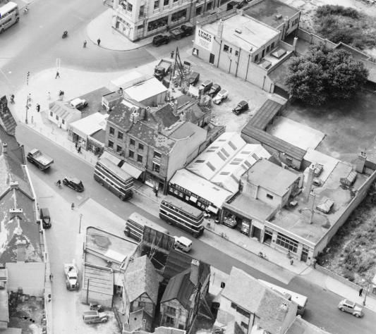
Bishop Street 1949
 |
| Streets and Roads - Bishop Street | |
|
Midland Red
|
41 of 129
Fri 20th Dec 2013 9:58am
Mods note : As recent posts have moved away from the thread subject (Bishop Street) towards the topic of The Canal Basin, I have copied or moved relevant posts into a separate thread entitled "Canal Basin", in order that this thread can remain on the subject of Bishop Street |
| Streets and Roads - Bishop Street | |
|
Helen F
Warrington |
42 of 129
Wed 1st Jan 2014 11:38pm
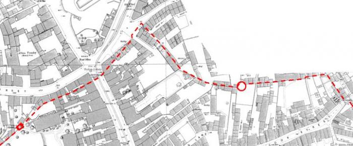
 Ok, I'm fairly sure the wall line I've marked is correct on the left side of Bishop's Gate but I'm not sure what it did between the gate and the round tower. Does anyone know the exact location?
 |
| Streets and Roads - Bishop Street | |
|
farrell72
Coventy |
43 of 129
Fri 16th Oct 2015 8:46pm
Knowing we have some very good Coventry historians on this site, they will remember a leather goods shop near the bottom of Bishop Street. I know close to it there was a Peeping Tom bust in the wall. My wife's grandfather Walter George Reed, a saddler by trade, worked in the shop for many years, we are not sure if he managed it or had shares in it. Would like to know the shop's name, and any pictures of it.
Graham. gfmarston
|
| Streets and Roads - Bishop Street | |
|
Annewiggy
Tamworth |
44 of 129
Fri 16th Oct 2015 9:39pm
There was at one time a leather goods manufacturer and retailer in Bishop Street called Tooby Atkins or Adkins |
| Streets and Roads - Bishop Street | |
|
Midland Red
|
45 of 129
Fri 16th Oct 2015 10:09pm
Tooby Atkins is mentioned here |
| Streets and Roads - Bishop Street | |
This is your first visit to my website today, thank you!
4,122,876Website & counter by Rob Orland © 2024
Load time: 686ms