|
Helen F
Warrington |
76 of 180
Thu 30th Mar 2017 7:06pm
On the right hand side you can see the Mattock and Spade with a sign behind the cart, behind the woman in the dark skirt and white blouse. That was number 16. On the Board of Health map, it is located at number 17 and the Malt house that probably served both locations was at the back of 17. |
| Streets and Roads - Jordan Well | |
|
Rob Orland
Historic Coventry |
77 of 180
Thu 30th Mar 2017 8:07pm
This might be a little closer.... although I feel I should've been a bit closer to the middle of the road. (Story of my life! |
| Streets and Roads - Jordan Well | |
|
Gumnut
Berridale NSW Australia |
78 of 180
Fri 31st Mar 2017 5:21am
It's difficult for me to imagine it as anything but the modern version. I would get completely lost if I were to visit the original layout and streets. it would be great fun though. caomhinsean@gmail.com
|
| Streets and Roads - Jordan Well | |
|
Helen F
Warrington |
79 of 180
Fri 31st Mar 2017 1:18pm
If anything the old layout was far easier to understand, although everyone seems to have trouble with where roads changed their name eg Fleet Street to Smithford Street, High Street to Earl Street to Jordan Well. Half the pictures I've got are labelled wrong.
One main east, west road. 3 main roads to the south. Most things end up at Broadgate. The north of the city is more complicated but there was only one main road north, south and you always had the churches to orientate yourself. It's the modern city that blocks natural flow. That's not a criticism, just a quirk of changing use. |
| Streets and Roads - Jordan Well | |
|
heathite
Coventry |
80 of 180
Thu 19th Oct 2017 7:34am
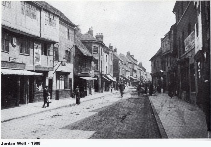
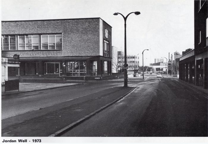
Jordan Well - two images for comparison.


|
| Streets and Roads - Jordan Well | |
|
Kaga simpson
Peacehaven, East Sussex |
81 of 180
Thu 19th Oct 2017 10:07am
Helen F. No one was really interested where roads began or ended, from the bank steps to the Gaumont was the High Street, from the Forum to Gosford Green was Ball Hill etc. It was always "it's about three doors down from the Empire", or "just past the Gas showrooms", "it's in thingamy street", or "go just past what's-a-names" - simple and easy, never went wrong. |
| Streets and Roads - Jordan Well | |
| Helen F |
82 of 180
Fri 20th Oct 2017 12:47pm
|
|
NeilsYard
Coventry |
83 of 180
Fri 20th Oct 2017 12:52pm
Looking at this one and the heavy bombardment that area took - I'm reminded about an article I read which stated that there is a belief that the Cathedral was deliberately targetted as an act of demoralization. This image certainly shows the surrounding area bore the scars.

|
| Streets and Roads - Jordan Well | |
|
Dreamtime
Perth Western Australia |
84 of 180
Fri 20th Oct 2017 2:28pm
On 20th Oct 2017 12:47pm, Helen F said:
That's how all of us used to navigate but that doesn't help me when trying to work out where some bewildered tourist artist thought they were.
Ye Olde pub on every corner used to be a good guide and that comes from one who has no sense of direction, what chance would I have, Helen.
|
| Streets and Roads - Jordan Well | |
|
Midland Red
|
85 of 180
Fri 20th Oct 2017 2:35pm
And now, of course, you're upside down as well |
| Streets and Roads - Jordan Well | |
|
Helen F
Warrington |
86 of 180
Fri 20th Oct 2017 2:40pm
Two great pics Heathite, but not from the same spot sadly. In the first picture on the north side of the road, Freeth Street and Cox Street are on either side of the middle line of the photo. On the right (south) side of the road, just beyond the two storey building, Whitefriars Street was built opposite Cox Street. In the second photo Bayley Lane is on the left and the first turning on the right is Much Park Street. Sadly I know of no early photo from that spot and only a Herbert Cox painting of the stretch beyond Bayley Lane looking north east. A few look the other way. As photogenic buildings were lost, the artists/photographers changed their favourite composition spots.
|
| Streets and Roads - Jordan Well | |
| Gilly |
87 of 180
Sat 21st Oct 2017 2:26am
|
|
Helen F
Warrington |
88 of 180
Sun 22nd Oct 2017 3:34pm
Dreamtime, I now know the names and locations of Coventry's pre war pubs better than the drunks who used to frequent them. They've been invaluable markers for the positions of things. They are often handily numbered and serve as a starting point to count up or down. eg I have a very old image of a row of buildings I think are on the south side of Jordan Well. I just found out that there was a substantial old cellar at number 47. When I locate the plot by comparing the Dun Cow 42 and the Cock 48 to the map, the cellar fits with where I thought this fancy house was. It's not cast iron proof but it helps. |
| Streets and Roads - Jordan Well | |
|
Dreamtime
Perth Western Australia |
89 of 180
Sun 22nd Oct 2017 3:47pm
Good on ya Helen. I think during my 'working years' at Herbert's most of the staff could tell you all the pubs around the Bell Green and surrounding areas. I think times have changed since then. I am amazed at what you find for us on the Forum so keep up the good work. |
| Streets and Roads - Jordan Well | |
|
NeilsYard
Coventry |
90 of 180
Sun 22nd Oct 2017 3:56pm
Pubs have always helped me |
| Streets and Roads - Jordan Well | |
This is your first visit to my website today, thank you!
4,034,081Website & counter by Rob Orland © 2024
Load time: 610ms