Dreamtime
Perth Western Australia
|
16 of 200
Fri 22nd Feb 2013 3:35am
On 21st Feb 2013 6:57pm, Old Lincolnian said:
The Church Bookshop was one of my favourite shops when I first came to Coventry.  I seem to remember it was in smaller premises in Trinity Street before it moved to Hertford Street.
Does anyone know why it was called the Church?
Hello Old Lincolnian,
I used to use the Church Bookshop frequently and could always get the literature there that I could not obtain at a normal book shop.
Shakespeare or any of the classics even religious books for school. This is the one in Hertford Street and it was such a dark little shop, but I spent a good few hours browsing, even the smell as you go in would get to you. I think is has been mentioned before. All my favourite shops seem to have disappeared now. 
|
|
Streets and Roads -
Albany Road / Butts
|
Rootes66
Dunfermline
|
17 of 200
Fri 22nd Feb 2013 11:53am
I remember the smell of the Church Bookshop too - the pleasant scent of new books, of printing ink and paper. I can recall it now. The shop was a bit like a long corridor.
Going back to the Butts, has anyone seen any photos of Hope Street. I can remember the place being pulled down in the early 60s. Stopped one day on my way to school. The guys had put a rope round the top half of one of the houses and tied it to the back of an antiquated caterpillar tractor (open topped of course) and the driver was wearing a duffle coat with the hood up to protect from the clouds of dust. He looked like a little monk. The tractor pulled several times before the building gave way and collapsed in the most enormous cloud of dust I've ever seen!
I also recall somewhere in those backstreets, maybe the other side of the Sherborne, a factory that produced a lot of smoke and pollution, possibly a foundry. I remember cycling across the bridge in Windsor Street in the early 60s and the whole area was covered in a cloud of acrid smoke some days. Does anyone remember this place and what it did?
|
|
Streets and Roads -
Albany Road / Butts
|
mick
coventry
|
18 of 200
Fri 22nd Feb 2013 7:14pm
That would be the Trafalgar Foundry in Trafalgar Street. One of the first jobs I did when I started with the Council was to help the Cov and Warwickshire Association for the Deaf move their club into the front building of the Foundry on a temporary basis whilst their new premises were being built at the Butts [where they still are]. They were being moved from Hill Street just above Leigh Mills to make way for the Ring Road. I can remember being fascinated by seeing snooker tables being reassembled.
Another thing I recall from this area was the 'cat man' who lived in a house in the Butts alongside the Summerland Tavern and possessed over 30 cats and rising! His front garden was enclosed in mesh and in the house he just added another layer of newspaper. He would have been impossible to relocate but his parents were reasonably affluent and bought him a cottage in the country. The demolition contractors would not touch the house and in the end the Fire Brigade had to burn it down. |
|
Streets and Roads -
Albany Road / Butts
|
Rootes66
Dunfermline
|
19 of 200
Fri 22nd Feb 2013 11:12pm
Very interesting, Mick. Definitely sounds like the place. Does anyone have an old map of that area with these old streets, which I suppose would border onto the old Spon Street and the GEC factory?
When they were knocking all that stuff down around 1961, I do remember there was a stand-off with the resident of one of the cottages on the Butts on the other side from Windsor Street, next to the far end of the Tech College. There was a row of single story houses, early 19th century and most of them got knocked down except for the last one, where the old guy there refused to move. It stood isolated for a while, but finally succumbed. Where was the Summerland Tavern? Nice name.
|
|
Streets and Roads -
Albany Road / Butts
|
dutchman
Spon End
|
20 of 200
Fri 22nd Feb 2013 11:48pm
On 22nd Feb 2013 11:12pm, Rootes66 said:
Very interesting, Mick. Definitely sounds like the place. Does anyone have an old map of that area with these old streets, which I suppose would border onto the old Spon Street and the GEC factory?
There's a discussion of the Trafalgar Foundry here and a map showing its location here.
On 22nd Feb 2013 11:12pm, Rootes66 said:
Where was the Summerland Tavern? Nice name.
Opposite the Butts Stadium close to the junction with Windsor Street. It's still there, at first renamed The Fob Watch and currently The Butts Retreat. The name derives from the area around a local dear-hunting lodge which was known as the Summerland.

|
|
Streets and Roads -
Albany Road / Butts
|
Dreamtime
Perth Western Australia
|
21 of 200
Sat 23rd Feb 2013 1:15am
Good Morning Dutchman hope you are managing to beat the cold.
I have noticed from you recent map above showing the courts around the Broomfield Tavern particularly those at the back.
When we were living there it was a grassy area long neglected and the old buildings had the top level showing large windows with the small panes. I should think there was a busy active housing area there in the 1900's. I would like to have seen what it looked like then.  |
|
Streets and Roads -
Albany Road / Butts
|
Midland Red
|
22 of 200
Sat 23rd Feb 2013 9:05am
On 22nd Feb 2013 11:12pm, Rootes66 said:
Where was the Summerland Tavern? Nice name.
There's a discussion topic here about this pub  |
|
Streets and Roads -
Albany Road / Butts
|
|
dutchman
|
23 of 200
Sat 23rd Feb 2013 4:30pm
|
|
dutchman
Spon End
|
24 of 200
Sat 23rd Feb 2013 4:31pm
On 23rd Feb 2013 1:15am, Dreamtime said:
I have noticed from you recent map above showing the courts around the Broomfield Tavern particularly those at the back.
When we were living there it was a grassy area long neglected and the old buildings had the top level showing large windows with the small panes. I should think there was a busy active housing area there in the 1900's. I would like to have seen what it looked like then.
It's hard to imagine now but until around 1960 the area in front of the stadium was also densely populated:
Old-Maps.co.uk |
|
Streets and Roads -
Albany Road / Butts
|
Dreamtime
Perth Western Australia
|
25 of 200
Sat 23rd Feb 2013 5:38pm
It certainly looked like it and I would not have thought they would have been there till the 60's.
I always considered Spon End area to be a gem for Coventry. Shame it has been so mutilated.
Thank you for the map Dutchman, just spotted the Broome on the left. |
|
Streets and Roads -
Albany Road / Butts
|
dutchman
Spon End
|
26 of 200
Sat 23rd Feb 2013 6:19pm
On 23rd Feb 2013 5:38pm, Dreamtime said:
It certainly looked like it and I would not have thought they would have been there till the 60's.
There's a picture in one of the local books of Sovereign Place taken around 1959 showing the cobbler's shop on the corner opposite the Summerland.
I'm surprised the old garage opposite Sovereign Row lasted as long as it did (1980). There was a proposal at one time to demolish both the garage and the Summerland and to replace them with an access road running parallel to the Butts from the tower block to Windsor Street but it was dropped in favour of relocating the garage next to the pub instead. |
|
Streets and Roads -
Albany Road / Butts
|
Rootes66
Dunfermline
|
27 of 200
Sat 23rd Feb 2013 11:32pm
Thanks for those two maps, Dutchman. Answered some questions I had from 50+ years ago. The first map you showed above of the Butts and Windsor Street appeared to date from the late 1960s as the left side of Windsor Street is still there while the other side and along the Butts have gone. Very interesting to see these old maps and the layout of the area and compare it with the view from today's bird's-eye on Google or Bing Maps. Nothing much left to even imagine what it was like.
The much earlier map (through the link) showing Sovereign Place is fascinating. I seem to remember this as a line of single-storey cottages in a terrace further up the Butts, and do remember them being pulled down one summer, either 1960 or 61. The one right on the end nearest the College remained standing for longer because of some dispute with the owner. I remember it very well, standing like an isolated chunk. The story was covered in the CET at the time. Presumably all these properties were compulsory purchase so they could be cleared. Do you know if a photo exists of this area?
This whole area between the Butts, the Sherbourne and Spon Street had a lot of history. When it was being knocked down, I was about 12 and had no appreciation of what was going. Cycled past every day but never went to explore the side streets. I regret that now, but there was lots of similar areas all over Coventry that got wiped out by the "brave new world" of the ring road.  |
|
Streets and Roads -
Albany Road / Butts
|
dutchman
Spon End
|
28 of 200
Sat 23rd Feb 2013 11:57pm
On 23rd Feb 2013 11:32pm, Rootes66 said: Do you know if a photo exists of this area?
There a couple of shots of the general area around the Butts stadium on Britain from Above but you need to sign in in order to zoom-in on the area of interest:
The Butts Sports Ground, Coventry, 1920
Sports Pitches at Butts Road, Coventry, 1927
|
|
Streets and Roads -
Albany Road / Butts
|
Rootes66
Dunfermline
|
29 of 200
Mon 25th Feb 2013 6:26pm
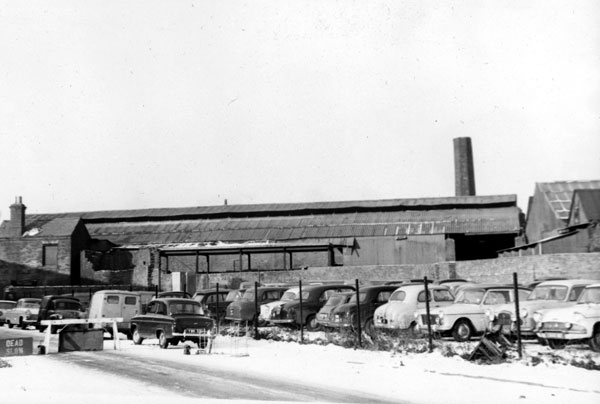
Interesting photos, taken before the Technical College was built. Can just make out the areas we've been discussing above, but right on the edge of the photos. On the 1920 photo in the middle distance behind St Thomas's, there's a large factory. I remember its frontage on Queen's Road. I've an idea it was called Alpha Engineering or something like that. Remember going there once or twice in the early 1960s to get a piece of steel, or get something drilled. Anyone remember anything about that place.
Had another search on Pictures of Coventry website. There are 11 pictures of Trafalgar Street, including one that looks like it might be the Foundry.
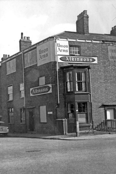
Also found this photo of the Union Arms in Hope Street, demolished 1965 according to the caption.
Some of the buildings in this area look old, possibly Georgian. Does anyone know when these were built and what they made in the top shops? Presumably watches in some. |
|
Streets and Roads -
Albany Road / Butts
|
dutchman
Spon End
|
30 of 200
Mon 25th Feb 2013 6:49pm
On 25th Feb 2013 6:26pm, Rootes66 said:
Some of the buildings in this area look old, possibly Georgian. Does anyone know when these were built and what they made in the top shops? Presumably watches in some.
They were originally weaver's cottages, many being converted to watch production later. 
|
|
Streets and Roads -
Albany Road / Butts
|


