
|
Midland Red
|
16 of 263
Fri 12th Apr 2013 1:15pm
Primrose: I found this for someone else who was asking about The Blue Pig PH :
The Blue Pig - it appears on Old Maps in 1888 between Ct13 and Ct14, and it is still marked on the 1905 map - this would make it no.33 Gosford Street
In Spennell's 1912 Directory no.33 is Pennant Engineering Co (sidecar specialists) so it looks as if it ceased to be a pub in the early years of the 20th century
The 1901 Census for no.33 shows Joseph Haycock, licensed victualler, but no reference to a pub name, and in 1911 there is a tailor living at no.33 |
| Streets and Roads - Gosford Street | |
|
dutchman
Spon End |
17 of 263
Fri 12th Apr 2013 1:29pm
LOL, it was officlally the Blue Boar Inn but locally referred to as the 'Blue Pig'. It became a cafe around 1907 but was the oddly-named 'Jordan Well Post Office' when I lived in Gosford Street:
 |
| Streets and Roads - Gosford Street | |
|
Primrose
USA |
18 of 263
Fri 12th Apr 2013 3:05pm
Thank you very much, gentlemen, for your responses. Mum will have no problem knowing where this was. My money is on Court 14 being Blue Pig Yard but it could easily be Court 13, I suppose. Thanks again! |
| Streets and Roads - Gosford Street | |
|
Midland Red
|
19 of 263
Sun 23rd Jun 2013 4:05am
Copied from another thread :
On 23rd Jun 2013 4:04am, dutchman said:
In those days there was also another bottleneck at the bottom of Gosford Street where the ancient malthouse projected some distance from the building line on the north side. It was removed some years later and the road considerably widened but I've never been able to determine exactly when?
Pictures of Coventry
NB: The pub on the left is the New Inn and not the Fox & Vivian as you might expect. |
| Streets and Roads - Gosford Street | |
|
Foxcote
Warwick |
20 of 263
Sun 23rd Jun 2013 9:39am
Dutchman, What would roughly be the numbers of the properties in the vicinity of the old Malthouse?
I wondered because I did find some details in the newspapers archive of Gosford Street properties being demolished..
Council Meeting Proposals and Decisions...
January 1901...
"That the necessary steps be taken for the compulsory purchase of Nos. 126, 127 and 128 Gosford Street."
October, 1903..
"decided to pull down nos. 124 and 125, Gosford Street, and the cottages at the rear adjoining on the east side the new street from Gosford Street to Whitefriars Street.
Another view..
Gosford Street |
| Streets and Roads - Gosford Street | |
|
Foxcote
Warwick |
21 of 263
Sun 23rd Jun 2013 1:51pm
On the 1901 census, 126/127 Gosford Street was recorded as Marry's, a Chemist. |
| Streets and Roads - Gosford Street | |
|
dutchman
Spon End |
22 of 263
Sun 23rd Jun 2013 2:08pm
On 23rd Jun 2013 9:39am, Foxcote said:
Dutchman, What would roughly be the numbers of the properties in the vicinity of the old Malthouse?
64 on one side of the street, 65 on the other.
The Malthouse was at the bottom of Gosford Street, Whitefriars Street is at the top!
|
| Streets and Roads - Gosford Street | |
|
Midland Red
|
23 of 263
Sun 23rd Jun 2013 2:30pm
On 23rd Jun 2013 1:51pm, Foxcote said:
Great photo MR, I noted 'Marston's Ales', a superior brew even now!
On the 1901 census, 126/127 Gosford Street was recorded as Marry's, a Chemist.
That's strange as in the 1912-13, Spennell's Directory it only goes up to 122, Sir Colin Campbell PH  |
| Streets and Roads - Gosford Street | |
|
dutchman
Spon End |
24 of 263
Sun 23rd Jun 2013 2:42pm
That's because they were pulled down to create the north end of Whitefriars Street. The Colin Campbell replaced an earlier pub called "The Griffin".
|
| Streets and Roads - Gosford Street | |
|
dutchman
Spon End |
25 of 263
Sun 23rd Jun 2013 2:46pm
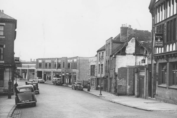
This is a close up from an aerial view of Gosford Street in 1930 showing The New Inn. Note the totally different style of windows and that the public entrance was on the side away from the camera, not facing the street.
 |
| Streets and Roads - Gosford Street | |
|
Helen F
Warrington |
26 of 263
Thu 27th Jun 2013 10:30pm
I don't know if I got this link from you guys in the first place but it's worth repeating.
[Sadly, the link given no longer exists]
Quite a few of Gosford street just before it turns into Far Gosford. St Georges Chapel and a building that used to be next to the Gate. The funny curved triangular thing in the wall by the first floor window was supposed to be the shoulder bone of the Dun Cow but was probably a whale shoulder bone. The buildings were where the Old Malt House was built.
Here's another picture of the gate done by Dr Troughton I believe but I think the gate had actually gone by the time he drew it. It could have been copied from earlier drawings of which the Pictures of Coventry web site has several.
Gosford Gate
 Both Dr Troughton and William Henry Brooke have left fantastic pictures of medieval Coventry.
 |
| Streets and Roads - Gosford Street | |
|
Helen F
Warrington |
27 of 263
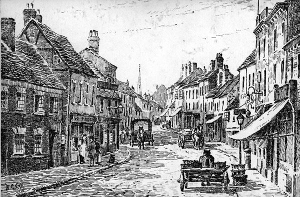
Thu 27th Jun 2013 11:35pm
The view from the gateway would have looked like this:-
Looking up Gosford Street (he New Inn is on the right.)
|
| Streets and Roads - Gosford Street | |
|
dutchman
Spon End |
28 of 263
Thu 27th Jun 2013 11:58pm
What isn't obvious from that sketch is just how far back from the street the buildings just beyond the New Inn were.
You can also see that at one time part of the pub building was used as a separate shop and also the bottleneck created by the Old Malthouse on the right.
|
| Streets and Roads - Gosford Street | |
|
Helen F
Warrington |
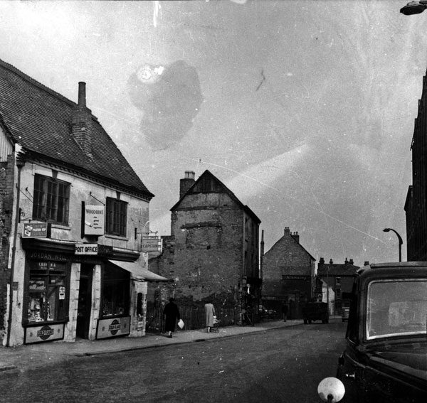
29 of 263
Fri 28th Jun 2013 12:19am
Yeah, it gets very confusing trying to match pictures to maps. The sketch is very accurate because I have an almost identical photograph except it shows one extra building on the right and four on the left. The first building on the sketch is the half building with the white walls in this photo
 Gosford street near site of Gate
And the building with the funny sign next door but one on the sketch is the Peacock I think. I have very little success counting buildings and comparing them to the street plans.
Gosford street near site of Gate
And the building with the funny sign next door but one on the sketch is the Peacock I think. I have very little success counting buildings and comparing them to the street plans. |
| Streets and Roads - Gosford Street | |
|
dutchman
Spon End |
30 of 263
Fri 28th Jun 2013 12:34am
On 28th Jun 2013 12:19am, Helen F said:
And the building with the funny sign next door but one on the sketch is the Peacock I think.
Yes it is Helen. The Peacock was famously demolished and rebuilt on the same site in a complete different style some time between the sketch being made and the photograph being taken. 
|
| Streets and Roads - Gosford Street | |

Website & counter by Rob Orland © 2024
Load time: 175ms