Midland Red
|
16 of 253
Wed 11th Jan 2012 3:16pm
Interesting to compare with Philip's photo taken last September
 |
|
Streets and Roads -
Spon End
|
dutchman
Spon End
|
17 of 253
Wed 11th Jan 2012 3:20pm
On 11th Jan 2012 1:27pm, Marina said:
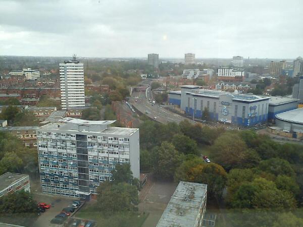
Hi all. I came across this photo of the flats and Ringway Rudge. I wonder when this was photo was taken. It was given to me, a long time ago.
Circa 1983. Compass Court is in the final stages of construction in the background with just a few more windows yet to be installed.
The picture was taken from the top of BT Mercury House in the Butts which is now the Ramada Hotel.
|
|
Streets and Roads -
Spon End
|
Marina
Ireland
|
18 of 253
Wed 11th Jan 2012 4:27pm
Thanks Dutchman for the info re this photo. About 1983 you say. I wondered where it had been taken from.
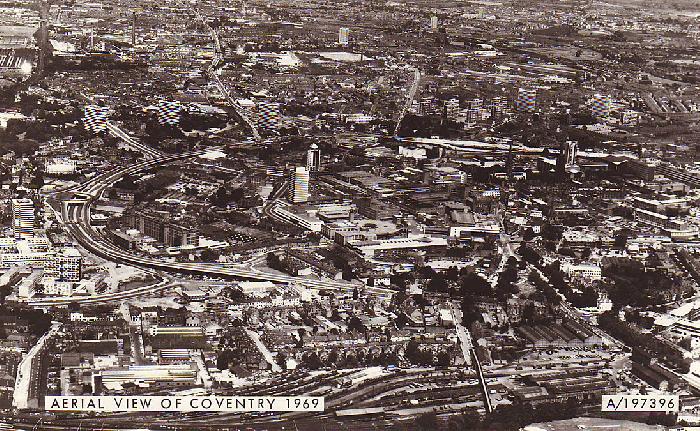
Midland Red, just looked again at Philip's aerial photo. Big changes. I am sure there must be an aerial view of same area pre 1960 to further compare?  |
|
Streets and Roads -
Spon End
|
NeilsYard
Coventry
|
19 of 253
Wed 11th Jan 2012 5:01pm
Yes interesting as it gives the exact position of the GEC compared to todays Skydome complex. Thanks for posting. |
|
Streets and Roads -
Spon End
|
Midland Red
|
20 of 253
Wed 11th Jan 2012 5:06pm
On 11th Jan 2012 4:27pm, Marina said:
Thanks Dutchman for the info re this photo. About 1983 you say. I wondered where it had been taken from.
Midland Red, just looked again at Philip's aerial photo. Big changes. I am sure there must be an aerial view of same area pre 1960 to further compare?
This is the best I can do - 1969, and you'll need a magnifying glass!
  |
|
Streets and Roads -
Spon End
|
Dreamtime
Perth Western Australia
|
21 of 253
Thu 12th Jan 2012 3:47pm
Great view if you zoom in MR. |
|
Streets and Roads -
Spon End
|
Marina
Ireland
|
22 of 253
Fri 20th Jan 2012 1:28pm
Thanks Dutchman for the great photos. Thomas Street was "across the river" from us in Trafalgar Street, or a walk down Trafalgar Street, passing the Cov Radiator factory and turning left at Sadlers grocery shop, passing one of the courts on the way. I hope my memory is correct here!! Nice to see. |
|
Streets and Roads -
Spon End
|
dutchman
Spon End
|
23 of 253
Fri 20th Jan 2012 4:39pm
This 1963 map shows the relative positions of Thomas Street and Trafalgar Street:

Albion Street is now the Ring Road. Moat Street is now the Butts Radial Relief Spur. The courtyards behind Thomas Street were still in use for some time after the relief road was built. The Globe public house (bottom right) would today be bang in the centre of the Croft Road roundabout! |
|
Streets and Roads -
Spon End
|
Marina
Ireland
|
24 of 253
Fri 20th Jan 2012 7:44pm
Thanks dutchman, It was Vincent St, across Sherbourne from Trafalgar St.!! I should have known that.
The map is great to see. |
|
Streets and Roads -
Spon End
|
NeilsYard
Coventry
|
25 of 253
Tue 14th Feb 2012 1:22am
Just reviving this Dutchman - looking at the photo of the Plaza I cannot work out where exactly I'm looking today to get that view? Is this going Westbound standing on whats now the Nissan dealership?
 |
|
Streets and Roads -
Spon End
|
dutchman
Spon End
|
26 of 253
Tue 14th Feb 2012 1:34am
You would be standing on the forecourt of what is now Godiva Carpets looking westwards towards the Nissan Showroom. At the time the photo was taken the cameraman would have been standing in front of a petrol station with a stock-car parked on the forecourt.
|
|
Streets and Roads -
Spon End
|
Baz
Coventry
|
27 of 253
Sun 17th Jun 2012 10:41am
The Arches in Spon End have another story to be told about them. In 1857, 23 of the 28 Arches fell down and the line was not in use for some time after. As you drive under them, you will see the difference in brick work. The replaced bridge was of bricks, the original was of sand stone. It happened only 7 years after the line had opened.
Always looking forward to looking at the past.
|
|
Streets and Roads -
Spon End
|
Harrier
Coventry
|
28 of 253
Sun 17th Jun 2012 11:20am
And another story about the arches.
The arches in Spon End was the starting line on May 9th 1908 of what 'can be considered the first true marathon to be held in Britain.' (The Guinness Book of the Marathon by Roger Gynn). The race Headquarters was the nearby Black Horse pub. It was one of half a dozen trials used for the 1908 Olympic Games in London but was nearest in length to the final Olympic Marathon distance from Windsor to the White City, the distance not being adopted officially until the early '20s. The Coventry race ran (!) via Meriden and Stonebridge to finish at the West Bromwich football ground.
|
|
Streets and Roads -
Spon End
|
TonyS
Coventry
|
29 of 253
Fri 7th Sep 2012 7:16am
On 7th Sep 2012 1:15am, dutchman said:
... There were very strict conditions about its appearance which had to be met and several earlier designs were rejected as being unsuitable for a conservation area.
I don't think the building that replaced it would have met similar conditions - so why was it allowed to be built there?
|
|
Streets and Roads -
Spon End
|
dutchman
Spon End
|
30 of 253
Fri 7th Sep 2012 2:21pm
The council totally ignored its own planning rules, not for the first or the last time. 
|
|
Streets and Roads -
Spon End
|

